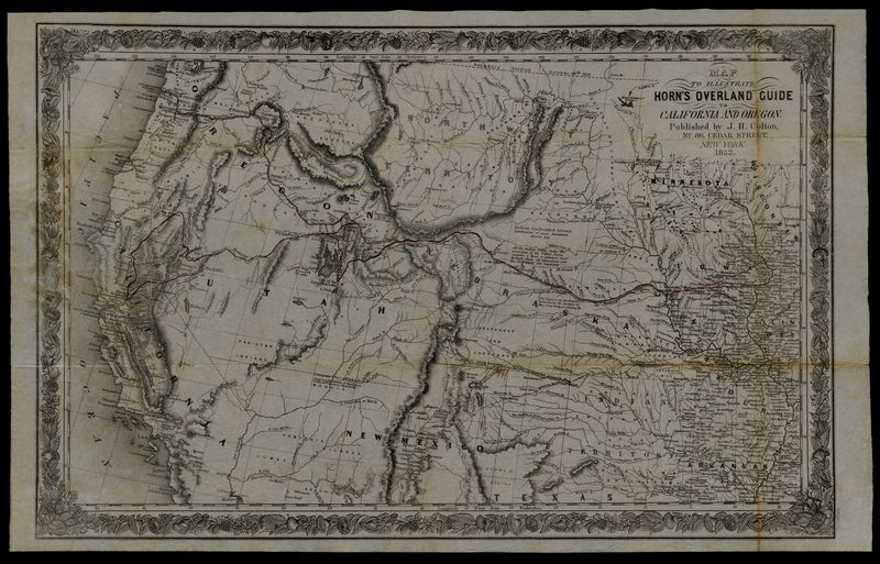
Horn, Hosea B. (fl. 1852) Map to Illustrate Horn's Overland Guide to California and Oregon
High-resolution images are available to schools and libraries via subscription to American History, 1493-1943. Check to see if your school or library already has a subscription. Or click here for more information. You may also order a pdf of the image from us here.
A high-resolution version of this object is available for registered users. LOG IN
Gilder Lehrman Collection #: GLC04152.02 Author/Creator: Horn, Hosea B. (fl. 1852) Place Written: New York, New York Type: Map Date: 1852 Pagination: 1 map ; 34.6 x 55 cm. Order a Copy
Map originally attached to Horn's overland guide (housed with books, GLC 4152.01), from the U.S. Indian sub-agency, Council Bluffs, on the Missouri River, to the City of Sacramento, in California containing a table of distances, and showing all the rivers, creeks, lakes, springs, mountains, hills, camping-places, and other prominent objects, with remarks on the country, roads, timbers, grasses, curiosities, etc.; the entire route having been tracked by a road-measurer, and the distances from place to place, and from the Missouri River, accurately ascertained. With a complete and accurate map. Published by JH Colton, No. 86 Ceder Street, New York 1852. Features detailed decorative border.
Citation Guidelines for Online Resources
The copyright law of the United States (title 17, United States Code) governs the making of photocopies or other reproductions of copyrighted material. Under certain conditions specified in the law, libraries and archives are authorized to furnish a photocopy or other reproduction. One of these specific conditions is that the photocopy or reproduction is not to be “used for any purpose other than private study, scholarship, or research.” If a user makes a request for, or later uses, a photocopy or reproduction for purposes in excess of “fair use,” that user may be liable for copyright infringement. This institution reserves the right to refuse to accept a copying order if, in its judgment, fulfillment of the order would involve violation of copyright law.