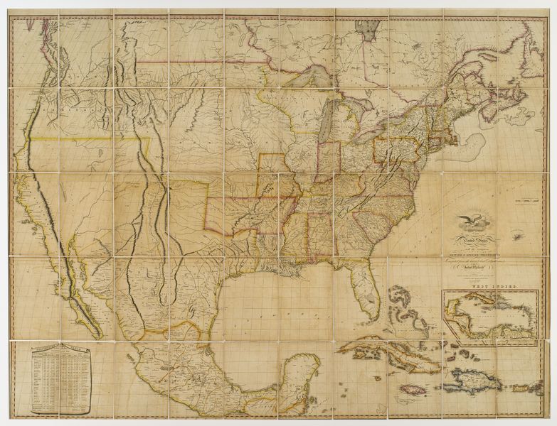
Melish, John (fl. 1820-1823) A Map of the United States with the contiguous British & Spanish possessions
High-resolution images are available to schools and libraries via subscription to American History, 1493-1943. Check to see if your school or library already has a subscription. Or click here for more information. You may also order a pdf of the image from us here.
A high-resolution version of this object is available for registered users. LOG IN
Gilder Lehrman Collection #: GLC04319 Author/Creator: Melish, John (fl. 1820-1823) Place Written: [Washington?] Type: Map Date: 1820, 1823 Pagination: 1 map 147.5 x 112 cm Order a Copy
The 1823 edition, but copyright 1820. Of Melish and his maps, Martin & Martin write (p. 115): "Recognizing the demand for geographical information on the American West was limitless for the foreseeable future, Melish undertook to accumulate a vast amount of descriptions, statistics, and maps, and in 1816 produced in six sheets his famous map. It proved so popular it was reprinted at least twenty-two times by the end of 1822. For the Texas area, Melish relied heavily on the surveys conducted by William Darby, who had personally surveyed much of the Sabine River area.... Melish's map significantly improved the descriptions and depictions of the Texas interior, but perhaps its most lasting value to history was its official association with the Adams-Onís Treaty." Phillips, America, p. 880. Taliaferro, p. 14n. Wheat, Transmississippi West 327. See also collateral GLC 7297, Melish's supplementary booklet.
Citation Guidelines for Online Resources
The copyright law of the United States (title 17, United States Code) governs the making of photocopies or other reproductions of copyrighted material. Under certain conditions specified in the law, libraries and archives are authorized to furnish a photocopy or other reproduction. One of these specific conditions is that the photocopy or reproduction is not to be “used for any purpose other than private study, scholarship, or research.” If a user makes a request for, or later uses, a photocopy or reproduction for purposes in excess of “fair use,” that user may be liable for copyright infringement. This institution reserves the right to refuse to accept a copying order if, in its judgment, fulfillment of the order would involve violation of copyright law.