Self-Paced Courses: Explore American history with top historians at your own time and pace!
1792
Ellicott, Andrew (fl. 1792)
[Map of Washington, D.C.].
Engraved folding map removed from the "Columbian Magazine." Included with a letter from Thomas Jefferson to Charles W. Dumas (GLC07104.01).
GLC07104.02
circa November 1813
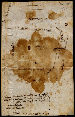
Gwinnett, Button (ca. 1735-1777)
[Map of Button Gwinnett's estate]
Hand sketched map of Gwinnett's estate in Georgia of 1450 acres showing the bordering properties. Mentions neighboring properties of James Spalding and Mary Maxwell. Circa date from typed label originally accompanying the document upon acquisition.
GLC00658.02
1784
Hills, John (fl. 1771-1796)
Sketch of the position of the British forces at Elizabeth-Town Point
Original by John Hill. Oversize engraved map with hand coloring of troop positions. Engraved by Faden. Nebenzahl, Battle Plans of the American Revolution, 146.
GLC01858
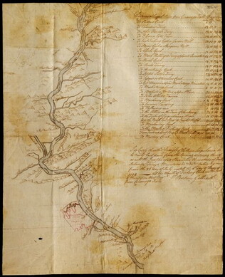
9 December 1801
Gleason, John (fl. 1796-1811)
[Copy of a survey map of land sold by Henry Knox to B. Joy of Boston]
Gleason and Robert Houston sign as surveyors. Depicts 16,340 acres of Waldo Patent land flanked by these notations: "Green, Waldo Heirs, Knox, Belfast, Northport, Lincolnville, and Bonapartte." A list of names is written in pencil within the area...
GLC02437.10341
23 July -6 August 1784
Galbraith, P. Bartrem (fl. 1784)
[Map of the Susquehanna River]
Drawn map of a portion of the Susquehanna River, with creeks, forts, and ferry landings noted. Also includes the distances to various points on the map. Noted as drawn above Canawago Falls, which is in Pennsylvania.
GLC02437.10583
Showing results 1 - 5