Self-Paced Courses: Explore American history with top historians at your own time and pace!
no date
Unknown
Map from Stratford to Poughkeepsie
This printed map appears to be cut out of a larger book or atlas. Neither Stratford nor Poughkeepsie is on the map. Has slight water damage/staining.
GLC02437.08401
1787
Tarleton, Banastre
A History of the campaigns of 1780 and 1781, in the Southern Provinces
With Newberry Library bookplate and library stamp of the Newberry. Accompanied by William Eaton fold-out map (49 x 66 cm), showing Cornwallis' marches through Virginia and Maryland (while Jefferson was governor of Virginia).
GLC03667
[rudimentary map of John Jackson's estate]
backside contains figures
GLC03769.008
1794/05/14
Whittle & Laurie
A new and general map of the middle dominion belonging to the United States...
The map shows part of the United States, from western New England to Michigan, and from Vermont to southern Virginia.
GLC04178
1784
Faden, William (ca. 1750-1836)
Plan of the Siege of Savannah...
Nebenzahl, Battle Plans of the American Revolution, 76.
GLC04316
1796/01/01
Arrowsmith, Aaron (fl. 1796)
A Map of the United States of North America
Handcolored. Each sheet is 66 cm high. The map shows the northwest territory outside the Union. A portion of Louisiana is included.
GLC04318
1786/08/15
Sayer, Robert
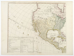
A Map of the Whole Continent of America... [Wall Map on 4 sheets]
GLC04412.01
1787/01/01
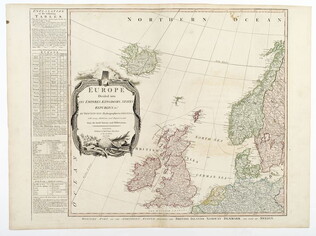
Europe divided into its Empires, Kingdoms, States... [Wall Map on 4 sheets]
This map has an attractive depiction of Algiers and the Barbery states which is slightly larger than that for GLC# 4412.04 (Africa)
GLC04412.02
1787/01/06
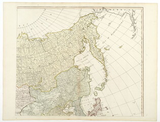
Asia and its islands, according to D'Anville... [Wall Map on 4 sheets]
GLC04412.03
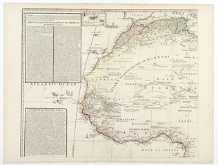
Africa with all its states, kingdoms... by S. Boulton [Wall Map on 4 sheets]
GLC04412.04
Showing results 11 - 20