Self-Paced Courses: Explore American history with top historians at your own time and pace!
[1863-1864]
Meigs, John R. (fl. 1850-1864)
Hand-drawn map in blue and red pencil, including towns of Newmarket, Hawkinsburg, and Woodstock.
Note on verso reads: "Field notes and maps found in pocket of J.R.M."
GLC07059.18
Hand-drawn map in red and blue pencil.
GLC07059.19
1863
Jenney, William Le Baron (1832-1907)
[Civil War map of Mississippi and Alabama]
Covers northern segments of the two states, showing towns, watercourses, railroads, and roads. Also shows Corinth and vicinity. The Tennessee River appears prominently, colored with a light blue paint wash. The map is painted and drawn on a coated...
GLC07086.03
circa 1861
Klosterman, H. (fl. 1861)
Map of the Seat of War in South Carolina
Shows the Atlantic coast from Savannah to Winyaw Bay, with Charleston featured prominently in the lower center. Indicates towns, roads, and some topographical features. Painted and drawn on a coated, fine weave "architect's" linen. Mostly black...
GLC07086.04
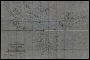
June 1864
Bartelle, Charles V. (fl. 1864)
Sketch showing defences and channels of Charleston Harbor.
This document is a map of Charleston Harbor depicting the major waterways and various forts in the area, among these is Fort Sumter. On the map it states that the map has been, "Copied by direction of Rear Admiral J. A. Dahlgren." The water on the...
GLC05919
Showing results 46 - 50