Self-Paced Courses: Explore American history with top historians at your own time and pace!
1884
Royce, C. C.
Map of the former territorial limits of the Cherokee Nation of Indians
From the Fifth Annual Report printed by N. Peters. (Map printed by C.C. Royce.)
GLC05689
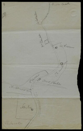
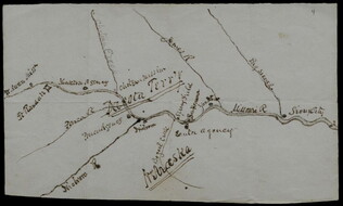
circa June 1872
Hemans, Daniel W. (fl. 1872-1881)
[Hand-drawn map of Dakota mission area]
Depicts the missions and Indian agencies along about fifty miles of the Missouri River west of Sioux City. Hemans discusses making the map for Frances Shiras to answer her question about the spatial relationship between the Santee, Yankton, and Ponca...
GLC02429.03
GLC02429.04
2 May 1864
Merrill, W. E. (William Emery) (1837-1891)
Map of Northern Georgia.
Created under the direction of Captain William E. Merrill, Chief Topographical Engineer. Lithographed map printed on paper squares mounted on cloth to facilitate folding. Contains handcoloring on roads and state borders. Based on Cherokee land maps...
GLC01740.02
30 September 1844
Pelham, William (1803-1879)
[Arkansas survey map depicting land claims]
Depicts a map of the Arkansas surveying district "shewing the extent of Public Survey's in said district on the 30th September 1844." Contains boundary lines, including the Cherokee and Choctaw line, the Louisiana Line, the Missouri line, and the...
GLC02210.02
Showing results 1 - 5