Self-Paced Courses: Explore American history with top historians at your own time and pace!
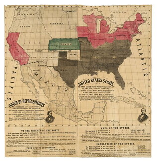
1856 ca.
To the free men of the North [election] [large cloth-backed lithographed map]
Free Labor Party abolitionist map used during the 1856 presidential campaign, printed, with hand-coloring in red, black and green.
GLC06662
1866
Wilson, Joseph S.
Reports of General Land Office, with Atlas
The report is printed in English, with four land promotion tracts in English, French, German and Swedish. Accompanied by an atlas containing 23 folding cloth color maps of each area. One of the maps is said to be the first to show Nevada with its...
GLC07453
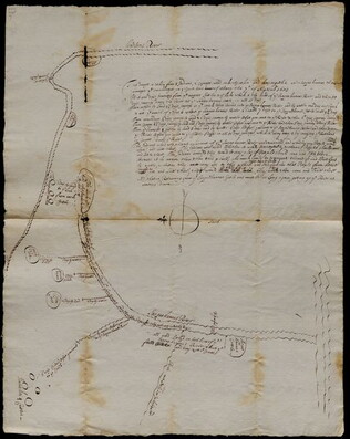
1683/09/07
Unknown
Settlements along the Susquehanna River
The map marks various settlements of the Senecas, Onondagas, and Cayugas along the Susquehanna River, and the length of travel between them. The accompanying text explains that a detailed account of the river is necessary so that settlers may find...
GLC03107.01923
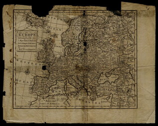
1758
Bennett, R. (fl. 1758)
Map of Europe describing its empires, kingdoms, and republics
GLC03107.05299
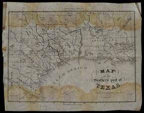
1833 ca.
Meiser, Edward S. (fl. 1833)
Map of the southern part of Texas
Map which belonged to Anthony Dey, a chief figure in the Galveston Bay & Texas Land Co. The map has had lands owned by the Company outlined in ink. Date inferred from provenance. Streeter, Texas 1137A and Philips Maps p. 843.
GLC02754
17 August 1900
unkown
Upper Silesia Plebiscite Area
Shows area of developed mineral resources, including coal bearing area. Also includes railways and district boundaries. Red line for final British proposal, Blue for French, and Green for League of Nations lines.
GLC02766.003
Upper-Silesian Plebiscite-Area
Final Results of the Plebiscite shown by districts.
GLC02766.009
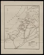
Map of Middle East
Includes railways and British Administration borders.
GLC02766.016
1958
Smith, Karl, (fl. 1938-1959)
A Map of the United States 1784-1844
One map illustrated by Karl Smith and published by Linweave Quality Papers, and Chicago Paper Company in 1958. The map features the United States as it was from 1784-1844. It includes the borders after the Louisiana Purchase in green. In yellow is...
GLC09861.02
1935
P.W.A. in Action
One map entitled, "P.W.A. in Action," dated 1935. Map consists of an illustration of the United States; including each of 50 states identified by a local Public Works program. Programs mentioned are related to housing, transportation, defense, museum...
GLC09879
Showing results 11 - 20