Self-Paced Courses: Explore American history with top historians at your own time and pace!
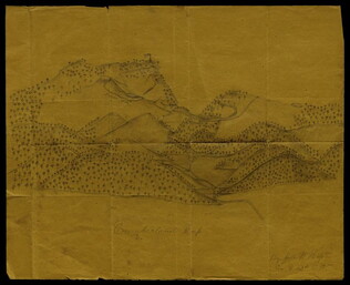
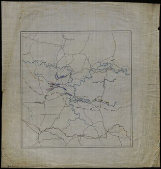
1864
Richardson, W.
[Battle map]
Hand-drawn battle map of the movements of the 23rd Army Corps during the siege of Atlanta, with positions of the Union and Confederate forces in Resaca, Marietta, and Atlanta.
GLC09321
1861
Bachmann, John (fl. 1849-1885)
Bird's-eye View of North and South Carolina and Part of Georgia
From the series: Panorama of the Seat of War. Locations of cities, towns, and military posts are identified as well as locations of naval ships. "Drawn from nature and lithographed by John Bachmann." Includes a key stating the distances between...
GLC03525
Bird's-eye View of Louisiana, Mississippi, Alabama and Part of Florida
From the series: Panorama of the Seat of War. Shows the Mississippi River delta where the river flows into the Gulf of Mexico. Locations of cities, towns, and military posts are identified as well as locations of naval ships. "Drawn from nature...
GLC03526
circa 1862-1865
Hopte, John W. (fl. ca. 1862-1865)
[Pencil illustration of the Cumberland Gap]
Depicts rolling mountainsides dotted with trees. Portrays forts, roads and other details specific to Civil War sites and events. Shows a rifle pit and an American flag waving atop a fortress. Signed by Hopte, who served in Company G, 42nd Regiment...
GLC03604
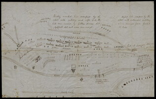
circa December 1862
Bush, George (fl. 1862)
[Map of Fredericksburg]
A fairly complete and accurate map of the Union position at Fredericksburg. Shows federal positions, pontoon bridges, geographic features, roads and houses used as hospitals. The position held by Gibbon's Division is slightly exaggerated.
GLC03607.08
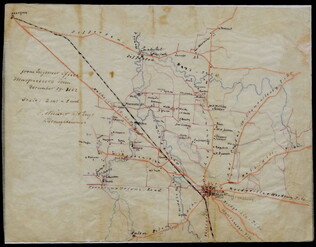
29 December 1862
Meister, C. (fl. 1862)
[Manuscript Civil War map of Murfreesboro, Tennessee]
Shows Murfreesboro and the areas north and west of it, along with names of property owners. Drawn shortly before the Battle of Stones River (Murfreesboro), providing evidence that General Braxton Bragg originally planned to attack the Union forces...
GLC02588
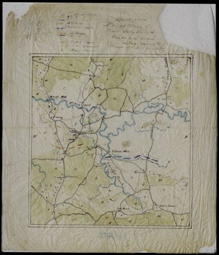
19 December 1862
Briscoe, James C. (d. 1869)
Position held by the 1st Divn. 3rd Corps After Having Repulsed the Enemy Decb. 13th 1862
Map sent with a letter written by Union General David B. Birney (see GLC02630.01). Shows the Union position on the battlefield at the Battle of Fredericksburg. Various picket lines, topographical features, and the locations of troops under generals...
GLC02630.02
1861-1865 ca.
Stanley, Lucius T. (1844-1934).
Archive of Civil War maps, mainly Atlanta campaign [word processed inventory available]
Collection of wartime manuscript maps with copies of other war items related to Stanley. 37 maps document Sherman's army from Chattanooga to Atlanta, the march to the sea and then up to the Carolinas. The last map (38) is the Battle of...
GLC02710
circa July 1864
Stanley, Lucius T. (1844-1934)
Battlefield Peach Tree Cr. Fought July 20 1864 Scale 4 in. pr. mi. from actual Survey by Topogs. of 1st Div 20 Corps
Notes houses, roads, military trails, locations of Union, including 1-3 Divisions of the 26th Corps and Confederate troops, lines of artillery, and barracks. Items are identifiable though the legend on the top of the map. Signed "Stanley fecit." Map...
GLC02710.35
[Union Civil War battlefield map of the Battle of Peachtree Creek]
Untitled draft of "Battlefield Peach Tree Cr. Fought July 20 1864 Scale 4 in. pr. mi. from actual Survey by Topogs. of 1st Div 20 Corps," found in GLC02710.35. Notes houses, Howel's Mill and Collier's Mill, a burned bridge, roads, and waterways...
GLC02710.36
Showing results 31 - 40