Self-Paced Courses: Explore American history with top historians at your own time and pace!
2 May 1793
Washington, George (1732-1799)
A Proclamation [printer's proof of neutrality proclamation]
Printer's broadside proof of Washington's neutrality proclamation printed at the Columbian Centinel (Boston). The date is inferred.
GLC02391
1 March 1777
Faden, William (ca. 1750-1836)
A topographical map of the North part of New York Island establishing the plan of Fort. Washington, now Fort Knyphausen
Depicts northern Manhattan's Fort Washington which was captured by British forces on 11/16/1776. Copper engraving with older contemporary color. Describes and maps the four attacks by General Knyphausen on Fort Washington. "Hudsons or North River"...
GLC02394
01 January 1823
Stone, William James (1798-1865)
Declaration of Independence [W.J. Stone facsimile on vellum]
The William J. Stone facsimile of the Declaration of Independence, printed on parchment, with Stone's imprint. Secretary of State John Quincy Adams, upon discovering the fragility of the original Declaration of Independence in 1820, ordered this...
GLC00154.02
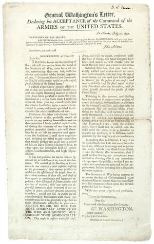
18 July 1798
General Washington's Letter Declaring his Acceptance of the Command of the Armies of the United States
Regarding the Quasi-War with France, Washington's support for the Administration and acceptance of commander in chief. Signed: "D.R. Slade" in upper right corner. Washington's letter is dated July 17, 1798 from Mount Vernon. The document is also...
GLC00265.04
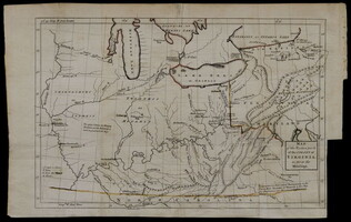
[1754]
Map of the western parts of the colony of Virginia, as far as the Mississip[p]i
Rare folding map of Eastern part of what is today the United States to the Mississippi River. With orange color supplied on the borders of Virginia. Shows Washington's route from Williamsburg to French Fort. Removed from book due to condition 1997.
GLC00419.02
Showing results 6 - 10
![Declaration of Independence [W.J. Stone facsimile on vellum]](/sites/default/files/styles/site_search_thumbnail_2x/public/collection-images-th/GLC00154.02_th.jpg?itok=kvckgwhb)