Self-Paced Courses: Explore American history with top historians at your own time and pace!
30 March 1774
Flucker, Thomas (1719-1783)
[Map of land]
A drawn map of land, likely located in Maine, deeded to Francis Waldo from Thomas and Hannah Flucker. Shows lakes, rivers, and boundary lines. Date taken from docket.
GLC02437.10645
1900
Gannett, Henry (1846-1914)
Proportion of Foreign Born to Total Population of the United States at the Twelfth Census 1900.
One map containing the results of the of the twelfth census of the foreign immigrant population in the United States printed in 1900. Results were compiled by geographer Henry Gannett. Map shows that the largest foreign populations were in the...
GLC09668
1815-1860
Unknown
[Map of Sanders property given to Joshua Sanders]
GLC09302.007
18 December 1943
Polgar, Lillian (fl. 1943-)
homemade map to Lillian and Frank's house
Hand drawn and colored map to Lillian and Frank Polgar's house. On the left of the drawing there are notes that say housewarming, and fifth wedding anniversary.
GLC09414.1568
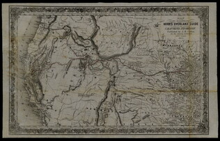
1852
Horn, Hosea B. (fl. 1852)
Map to Illustrate Horn's Overland Guide to California and Oregon
Map originally attached to Horn's overland guide (housed with books, GLC 4152.01), from the U.S. Indian sub-agency, Council Bluffs, on the Missouri River, to the City of Sacramento, in California containing a table of distances, and showing all the...
GLC04152.02
Showing results 6 - 10