Self-Paced Courses: Explore American history with top historians at your own time and pace!
unknown
Unknown
[Allied invasion of Normandy sectors]
A map of the five areas where Allied troops invaded Normandy on June 6, 1944.
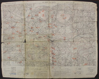
GLC09557.06
September 1943
U.S. Army
La Haye du Puits [French]
A map of La Haye-du-Puits, France. There are numbers handwritten in orange on the map, but it is unclear what they represent. The back of the map has "La Haye Du Puits 31/18 S.W.," written in red.
GLC09557.07
18 December 1943
Polgar, Lillian (fl. 1943-)
homemade map to Lillian and Frank's house
Hand drawn and colored map to Lillian and Frank Polgar's house. On the left of the drawing there are notes that say housewarming, and fifth wedding anniversary.
GLC09414.1568
1943/03-1944/12
Follweiler, Frank (fl. 1944-1945)
D-Day Diary labeled "address book"
Diary kept in a green cloth address book written on board Tank Landing Ship LST-383 officer. Many of the diary entries are more like notes (p. "VII"): "Left ...Eng. Mon. June 5 for our fourth invasion ... D-Day is Tues June 6 .... Arrived Tues June 6...
GLC07239
1934-1963
Southern, Neta Snook (1896-1991)
Diary of Neta Snook Southern
This daily diary book primarily includes lists and notes regarding Snook Southern's farm and home. The diary is used sporadically for a nineteen year period. Also included with the diary are various newspaper clippings and receipts.
GLC07243.003
1935
P.W.A. in Action
One map entitled, "P.W.A. in Action," dated 1935. Map consists of an illustration of the United States; including each of 50 states identified by a local Public Works program. Programs mentioned are related to housing, transportation, defense, museum...
GLC09879
Showing results 11 - 16