Self-Paced Courses: Explore American history with top historians at your own time and pace!
1792
Pierpont, Joseph (fl. 1792)
[Map of land]
Map of the land by the Penobscot River. Water is drawn with blue watercolor ink. Shows the division of land into different plots.
GLC02437.10593
1795
Gleason, John (fl. 1796-1811)
Map of surveyed land possibly located in Maine. Titled, "THE SOUTH LINE OF the 50000 Acres Run By John Gleason Junr 1795 No 1." Covers three miles and a half of land and includes notes on the quality of land. Document is partially printed with...
GLC02437.10598
circa 1796-1806
A sketch of land surveyed by John Gleason. Cover 50,000 acres of land likely located in Maine. Shows a pond and various land marks in water colors and has a partially colored border.
GLC02437.10650
circa 1784-1806
Unknown
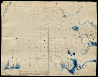
A drawn map of lands near the Penobscot River in Maine. Land is noted as belonging to the heirs of Brigadier [General Samuel] Waldo. Lakes and rivers are noted in blue water color. Includes a drawn compass showing cardinal directions.
GLC02437.10652
circa 1790
Noted as a copy. Drawn sketch of a plan for the northwestern part of the Waldo Patent located in Maine. Depicts county lines and the northern and western boundaries of the Waldo Patent. Date was added later in pencil.
GLC02437.10666
no date
Map from Stratford to Poughkeepsie
This printed map appears to be cut out of a larger book or atlas. Neither Stratford nor Poughkeepsie is on the map. Has slight water damage/staining.
GLC02437.08401
1680-1800
[Middle Passage iron bilboes, 18th century]
One set of middle passage iron bilboes, circa 1680-1800. Item is an iron restraint for ankles or wrists used on slave ships to fasten two enslaved people to each other. Consist of an iron bar running through two c-shaped cuffs. One end of the rod has...
GLC09707
1787
Tarleton, Banastre
A History of the campaigns of 1780 and 1781, in the Southern Provinces
With Newberry Library bookplate and library stamp of the Newberry. Accompanied by William Eaton fold-out map (49 x 66 cm), showing Cornwallis' marches through Virginia and Maryland (while Jefferson was governor of Virginia).
GLC03667
[rudimentary map of John Jackson's estate]
backside contains figures
GLC03769.008
1794/05/14
Whittle & Laurie
A new and general map of the middle dominion belonging to the United States...
The map shows part of the United States, from western New England to Michigan, and from Vermont to southern Virginia.
GLC04178
Showing results 11 - 20