Self-Paced Courses: Explore American history with top historians at your own time and pace!
circa 1864-1865
Unknown
[Gardner Civil War photographs: Meade, Grand Review, etc]
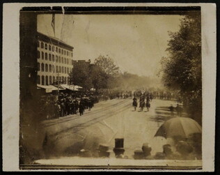
Gardner-Ordway Collection. Picture of the Grand Review of the Army of the Tennessee, May 24, 1865. Photograph 13, neg. number 1258.
GLC05508.012.13
Gardner-Ordway Collection. Picture of the Grand Review of the Army of the Tennessee, May 24, 1865. Photograph 14, neg. number 1259.
GLC05508.012.14
Gardner-Ordway Collection. Picture of the Grand Review of the Army of the Tennessee, May 24, 1865. Photograph 15, neg. number covered by a mount.
GLC05508.012.15
Gardner-Ordway Collection. Picture of the Grand Review of the Army of the Tennessee, May 24, 1865. Photograph 16, neg. number 1268.
GLC05508.012.16
Gardner-Ordway Collection. Picture of the Grand Review of the Army of the Tennessee, May 24, 1865. Photograph 17, neg. number 1282.
GLC05508.012.17
circa 1864
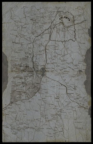
[Manuscript Civil War map of Atlanta and vicinity]
Detailed map on blue lined paper of Atlanta and environs from General Sherman's Atlanta campaign. Shows roads, railroads, forests, and rivers. Directions and latitude not given.
GLC01924
1856-1870 ca.
Civil War photograph collection: Brady, Gardner; Lincoln [separate inventory]
Word processed inventory available. Approximately 2000 photographs, mostly period, from the Civil War era. Includes battles, portraits, group portraits of regiments and officers, medical photographs (3), retouched original prints or photographs with...
GLC05111
1861-1865 ca.
Caskie family (fl. 1861-1865)
Collection of Civil War carte de visite photographs [decimalized]
Mostly post-war reprints and imprints. Various sizes. From the Caskie Family.
GLC01442
circa May 1863
Baum, A. Clark (b. 1832)
[Manuscript Civil War map of the Battle of Chancellorsville]
Shows the U.S. Mine Ford. Also shows three pontoon bridges over the Rappahannock River, various Confederate batteries and rifle pits, hospital locations, and the location of Fitzhugh House. References to a skirmish on a Sunday night and a shelling...
GLC06013.01
circa December 1862
[Manuscript Civil War map of the Battle of Fredericksburg]
Shows bridges, batteries, hospitals, positions of Confederate sharpshooters, the railroad and Falmouth Station, and various buildings, including Lacy House. Also shows the movement across a bridge of Captain Wesley Brainerd. There are photographs...
GLC06013.02
circa 7 December 1862
Brooks, Alfred F. (fl. 1862-1863)
[Manuscript Civil War map of the Battle of Murfreesboro]
Hand-colored map depicting Confederate and Union troop and artillery positions, and the location of a hospital. Brooks was the Acting Topographical Engineer, 2nd Brigade, 5th Division, 14 Army Corps.
GLC06162
circa 5 May 1862
Smith, Henry W. (1836-1869)
[Manuscript Civil War map of the Battle of Williamsburg]
Shows the troop positions of forces under Union generals Philip Kearney and Joseph Hooker, as well as the Confederate line. Also shows the open field where the combatants met, Fort Magruder, and other structures. Smith is identified on the docket...
GLC06161
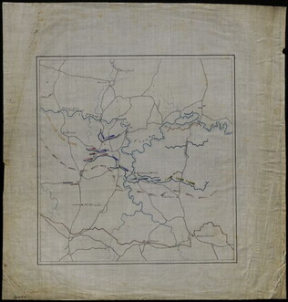
Stephens, Asbury L. (b. 1843)
[Manuscript Civil War map of General Sherman's Atlanta campaign]
Shows the route of Sherman's march from Chattanooga, Tennessee starting on 4 May 1864 and culminating with the siege of Atlanta on 8 September 1864. Drawn in black, red, yellow, and green ink on linen.
GLC04498.01
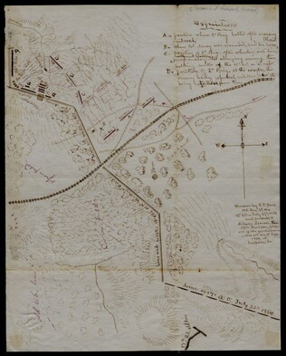
27 July 1864
Snell, J.P. (fl. 1864)
[Manuscript Civil War map of the Battle of Atlanta]
Presented by Snell to Asbury Stephens, "one of the participants this 23d. day of Sept. 1864, at Eastpoint, Ga." Shows where the 2nd Brigade crossed the railroad, moved into battle, position at the works, and its efforts to repulse the Confederates...
GLC04498.03
1864-1865 ca.
[Carte-de-visite of a black soldier in the Civil War]
Photograph of a First Sergeant in the U. S. Colored Troops.
GLC08976
circa November 1863
[Manuscript Civil War map of the Battle of Rappahannock Station]
Shows pontoon bridges, batteries, the Orange & Alexandria Railroad, various fortifications, the locations and movements of the 5th and 6th Army Corps, and the routes of Confederate reinforcements. Also shows General John Sedgwick's headquarters....
GLC06013.03
3 portraits of Civil War soldiers in uniform: 1 quarter type, 2 sixth type
3 tintype images accompanied by a "Union" military case with cannon.
GLC03090.04
Gardner, Alexander (1821-1882)
Group portrait of Civil War officers at the front by Gardner
19 men seated and standing in two rows in various poses.
GLC00557
no date
[View of an interior of a Civil War era hospital with patients]
Reproduced photograph of a hospital interior, possibly one that Dr. Thomas A. McParlin oversaw.
GLC02649.48
circa July 1864
Stanley, Lucius T. (1844-1934)
[Union Civil War battlefield map of the Battle of Peachtree Creek]
Untitled draft of "Battlefield Peach Tree Cr. Fought July 20 1864 Scale 4 in. pr. mi. from actual Survey by Topogs. of 1st Div 20 Corps," found in GLC02710.35. Notes houses, Howel's Mill and Collier's Mill, a burned bridge, roads, and waterways...
GLC02710.36
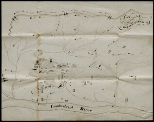
circa January 1863
[Manuscript Civil War map of Dover, Tennessee, showing battlefield and artillery]
Shows Confederate line of batteries, roads, rivers, and ravines. Also shows the town layout with gun placements and building locations. Approximately forty buildings appear, including the headquarters of the 83rd Illinois Regiments, Colonel A.C...
GLC04042.01
February 1865
[Manuscript Civil War map of the siege of Columbia, South Carolina]
Circular map showing the position of the 4th Division of the 13th Army Corps, rivers, railroads, and roads around Columbia. General Sherman's siege was on 16-17 February 1865. Drawn in brown and pink ink.
GLC04498.06
22 March 1943
[Photograph of World War II African American Private]
Reverse contains illegible handwritten name of Private with "Fort Jackson 3/22/1943".
GLC09568
Stanley, Lucius T. (1844-1934).
Archive of Civil War maps, mainly Atlanta campaign [word processed inventory available]
Collection of wartime manuscript maps with copies of other war items related to Stanley. 37 maps document Sherman's army from Chattanooga to Atlanta, the march to the sea and then up to the Carolinas. The last map (38) is the Battle of...
GLC02710
Cartes de visite of Civil War era Nothern statesmen and others [decimalized]
GLC05596
Showing results 26 - 50