Self-Paced Courses: Explore American history with top historians at your own time and pace!
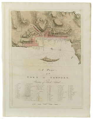
1781
Barres, Joseph Frederick Wallet des (1722-1824)
A Plan of the town of Newport
Companion print and detail of #3103.02, the chart of Rhode Island. Not in Nebenzahl, Battle Plans of the American Revolution.
GLC03103.03
1777
Faden, William (fl. 1750-1836)
A Plan of the city and environs of Philadelphia
Surveyed by N. Scull and G. Heap, engraved by William Faden. Includes military information relative to the American Revolution. Also has an inset image of Independence Hall, where the Declaration of Independence was adopted.
GLC02118
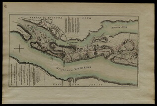
1779
Plan of Fort Montgomery and Fort Clinton
From the Atlantic Neptune. Engraved and tinted map showing the Hudson River by Anthony's Nose with the Americans' chains across the river. Plate no. 19. (The map mistakenly calls the mountain "St. Anthony's Nose.") Nebenzahl, Battle Plans of the...
GLC01850
circa 1775-1776
Unknown
[Battle plan for the siege of Boston Harbor]
Mapped battle plan for an American siege of Boston Harbor. Shows boats and some major geographic markers. For written plans see GLC02437.00231.
GLC02437.00232
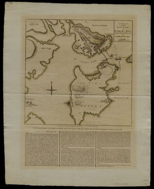
27 November 1775
Sayer, Robert
A Plan of the Battle on Bunkers Hill fought on the 17th of June 1775.
This document is a printed map of the Battle of Bunker Hill, designating the positions of American and British forces. Printed by R. Sayer and J. Bennet. Underneath the map is a written description of the Battle taken from a letter written by General...
GLC04760.01
circa 1780
A sketch of the operations before Charlestown, the capital of South Carolina
Large engraved map showing military operations, fortifications and outlying plantations, together with shallows and swamps. Shows positions of the various army units and notes that the Americans surrendered the city on 12 May 1780. Imprint from...
GLC01859
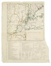
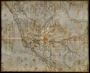
1 November 1776
Hawkes, W. (fl. 1776)
The Country twenty-five miles round New York
Irregular shaped paper. Engraving with letterpress chronological table of events from 1773-Oct. 1776, engraved by J. Barber and printed by W. Hawkes. Irregularly shaped. Nebenzahl, Battle Plans of the American Revolution, 110, who notes that a later...
GLC02005
01 July 1778
Faden, William (ca. 1750-1836)
British camp at Trudruffrin [Penna.] from the 18th to the 21st of September 1777...
title continues: "...with the attack made by Major General Grey against the rebels near White Horse Tavern, on the 20th of September. Drawn by an Officer on the Spot." Engraved and Published by W. Faden. Depicts the positions of various regiments and...
GLC04312
1 March 1777
A topographical map of the North part of New York Island establishing the plan of Fort. Washington, now Fort Knyphausen
Depicts northern Manhattan's Fort Washington which was captured by British forces on 11/16/1776. Copper engraving with older contemporary color. Describes and maps the four attacks by General Knyphausen on Fort Washington. "Hudsons or North River"...
GLC02394
01 March 1777
A topographical map of the North[er]n part of New York Island, Exhibiting the Plan of Fort Washington, now Fort Knyphausen, With the Rebels Lines to the Southward, which were Forced by the Troops under the Command of the Rt. Hon[ora]ble Earl Percy...
Title continues: "on the 16th Nov[embe]r 1776, and Survey'd immediately after by order of his Lordship by Claude Joseph Sauthier. To which is added the Attack made to the North by the Hessians. Survey'd by Order of Lieut[enan]t Gen[era]l Knyphansen."...
GLC03237
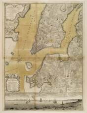
1776
Ratzer, Bernard
Plan of the City of New York in North America
Engraved by Jeffrey and Fagan. Oversize engraving showing lower Manhattan Island, part of Brooklyn and Hoboken, N.J. A cartouche extending across the bottom has a panoramic "South West View of the City of New York." Based upon the survey of 1766...
GLC02006
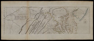
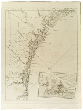
1775
Fry, Joshua (fl. 1775)
A Map of the inhabited part of Virginia... [compiled with Peter Jefferson]
There are two prints in this document set, both are copper engravings with original outline color added. They combine to form a single map of a portion of the Colonies. The first is of Eastern Pennsylvania with the misspelling "Pensilvania", from...
GLC03557
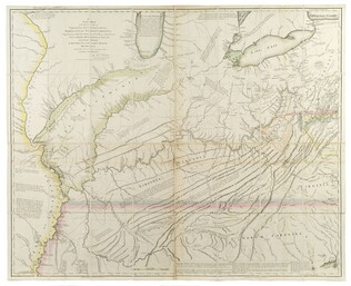
1778
Hutchins, Thomas (1730-1789)
A New map of Virginia, Pennsylvania....[with book:] A Topographical description
First edition, second issue. One of the most important early geographical descriptions of the West. Graff 2029, Howes H846. Accompanied by book. Not in Nebenzahl, Battle Plans of the American Revolution. Ex-Newberry Library. The map on light...
GLC03638
[1768/11]
Indian Boundary Line as Settled by Sr. William & them in Nov[ember[ 1768
GLC03107.02166
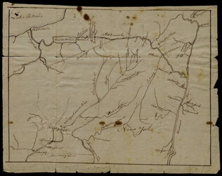
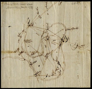
8 January 1777
[Map of roads in the vicinity of Morristown, New Jersey]
Indicates roads, some natural features, landmarks ("court house," "Whites Tavern Genl Lees," bridge, landing, etc.), outlying towns, and distance between points on the map. Indicates the location of towns surrounding Morristown. Notes the position...
GLC02437.09543
Montrésor, John (1736-1799)
A Plan of the City of New York & its environs
Actual title: "A Plan of the City of New-York & its environs..." Shows Manhattan Island up to Greenwich Village. Hand colored.
GLC04315
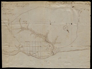
3 August 1781
Lincoln, Benjamin (1733-1810)
[Map of Charleston, South Carolina]
Manuscript map of Charleston, South Carolina showing the coastline, various rivers and geographic features, certain structures and county names. Date and creator inferred, based on the presumption that this map accompanies GLC02437.01112.
GLC02437.01113
circa 1782
Erskine, Robert (1735-1780)
[Map of South Carolina]
A manuscript copy of a printed map of a portion of South Carolina. Shows lakes, rivers, streams, forest, towns, counties, and possibly roads. Noted, "Part of SOUTH CAROLINA copied by R. Erskine F. R. S. from A Map published in London 1771." Docket...
GLC02437.10611
1780-1781
The Atlantic Neptune [selected maps and charts]
GLC03103
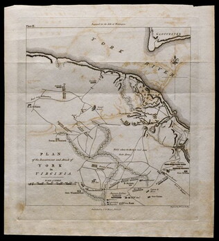
October 1781
[Map of Yorktown, Virginia]
Drawn map of Yorktown, Virginia. Shows roads, rivers, and other land markings, but not fortifications. With Cornwallis autograph note written across the front: "you will deliver the town immediately." Likely created by the British right before the...
GLC02437.10669
1780
Untitled chart of the coast of Georgia and South Carolina [Savannah]
Includes small plan of the siege of Savannah in a cartouche.
GLC03103.15
1781, reprint Philadelphia 1807
Plan of the investment and attack of York in Virginia [from Life of Washington]
Plate IX. Shows Yorktown. Published by C. P. Wayne; engraved by Francis Shallus.
GLC04760.02
Showing results 26 - 47