Self-Paced Courses: Explore American history with top historians at your own time and pace!
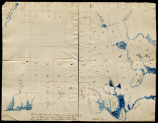
1792
Pierpont, Joseph (fl. 1792)
[Map of land]
Map of the land by the Penobscot River. Water is drawn with blue watercolor ink. Shows the division of land into different plots.
GLC02437.10593
1846
Mitchell, Augustus S. (fl. 1846)
Map of Texas, Oregon and California [pocket atlas]
Full title: A New Map of Texas, Oregon and California with the Regions Adjoining. Compiled from the Most Recent Authorities. First printing of this landmark map of the American West. Baughman, Kansas in Maps, p. 35. Graff 2841. Howes M685. Martin &...
GLC02130
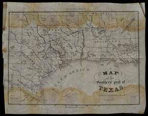
1833 ca.
Meiser, Edward S. (fl. 1833)
Map of the southern part of Texas
Map which belonged to Anthony Dey, a chief figure in the Galveston Bay & Texas Land Co. The map has had lands owned by the Company outlined in ink. Date inferred from provenance. Streeter, Texas 1137A and Philips Maps p. 843.
GLC02754
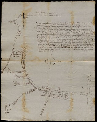
1683/09/07
Unknown
Settlements along the Susquehanna River
The map marks various settlements of the Senecas, Onondagas, and Cayugas along the Susquehanna River, and the length of travel between them. The accompanying text explains that a detailed account of the river is necessary so that settlers may find...
GLC03107.01923
1866
Wilson, Joseph S.
Reports of General Land Office, with Atlas
The report is printed in English, with four land promotion tracts in English, French, German and Swedish. Accompanied by an atlas containing 23 folding cloth color maps of each area. One of the maps is said to be the first to show Nevada with its...
GLC07453
1958
Smith, Karl, (fl. 1938-1959)
A Map of the United States 1784-1844
One map illustrated by Karl Smith and published by Linweave Quality Papers, and Chicago Paper Company in 1958. The map features the United States as it was from 1784-1844. It includes the borders after the Louisiana Purchase in green. In yellow is...
GLC09861.02
1900
Gannett, Henry (1846-1914)
Proportion of Foreign Born to Total Population of the United States at the Twelfth Census 1900.
One map containing the results of the of the twelfth census of the foreign immigrant population in the United States printed in 1900. Results were compiled by geographer Henry Gannett. Map shows that the largest foreign populations were in the...
GLC09668
Showing results 1 - 7