Self-Paced Courses: Explore American history with top historians at your own time and pace!
30 March 1774
Flucker, Thomas (1719-1783)
[Map of land]
A drawn map of land, likely located in Maine, deeded to Francis Waldo from Thomas and Hannah Flucker. Shows lakes, rivers, and boundary lines. Date taken from docket.
GLC02437.10645
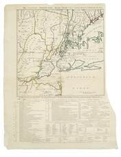
1 November 1776
Hawkes, W. (fl. 1776)
The Country twenty-five miles round New York
Irregular shaped paper. Engraving with letterpress chronological table of events from 1773-Oct. 1776, engraved by J. Barber and printed by W. Hawkes. Irregularly shaped. Nebenzahl, Battle Plans of the American Revolution, 110, who notes that a later...
GLC02005
circa 1863-1865
Hoyt, Frank A. (fl. 1863-1865)
[Manuscript drawing of the camp of the 3rd Wisconsin Cavalry Regiment]
Shows the various buildings and structures in camp, including barracks, a sawmill, barns, and a steam furnace. The buildings are numbered and there is a corresponding legend on the verso. Drawn in pencil with a colored flag. The regiment operated...
GLC03050
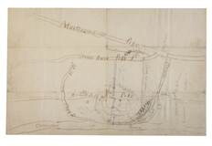
circa 25 December 1864
Tower, Zealous Bates (1819-1900)
[Pencil illustration depicting the area near Nashville, Tennessee]
Autograph map depicts roads, rivers, fortifications and estimated troop numbers and locations near Nashville. Tower, chief engineer of Union defenses at Nashville, possibly transmitted this map with a letter (refer to GLC00849.01) to William P...
GLC00849.02
1865
General Benham's winter camp near Poplar Grove Church, Va., with photo of troops
Printed map, "Winter Camp, Detachment 50th N.Y.V. Engineers" Brevet Colonel I. Spalding Commanding, near Poplar Church, Virginia, Army of the Potomac, 1865. Has been partially hand colored. An original albumen photograph of soldiers with musical...
GLC00919.26
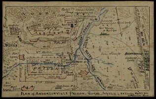
July 1864
Sneden, Robert Knox (1832-1918)
Plan of Andersonville Prison
Plan of the prison camp drawn by Sneden, a member of the 40th New York Volunteers imprisoned there in 1863-1864. Completed in ink and colored pencil. Sneden's map differs from other contemporary sketches.
GLC02244
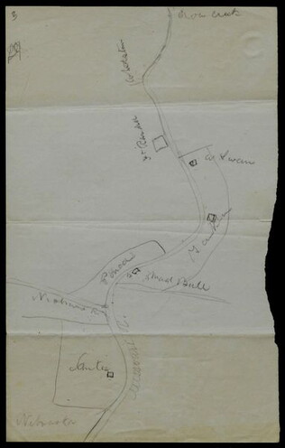
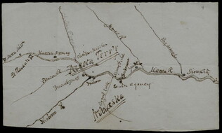
circa June 1872
Hemans, Daniel W. (fl. 1872-1881)
[Hand-drawn map of Dakota mission area]
Depicts the missions and Indian agencies along about fifty miles of the Missouri River west of Sioux City. Hemans discusses making the map for Frances Shiras to answer her question about the spatial relationship between the Santee, Yankton, and Ponca...
GLC02429.03
GLC02429.04
1860
Unknown
Map of Georgetown and the City of Washington
GLC09118.53
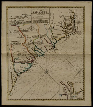
circa 1696
Sanson, Nicholas (1600-1667)
Carte generale de la Caroline dresse sur les memoirs le plus nouveaux
Map of North and South Carolina in an early period of settlement. Includes an inset of the area around Charleston, which locates plantations. This copy has a pencil note "1740" in margin, but no evidence for dating. In fact, this map remained...
GLC05236
Showing results 1 - 10