Self-Paced Courses: Explore American history with top historians at your own time and pace!
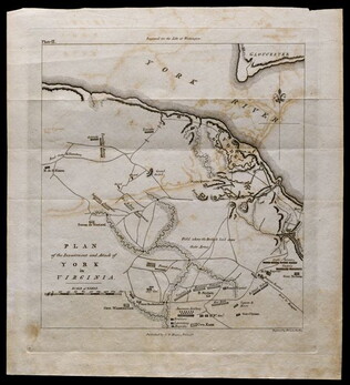
1781, reprint Philadelphia 1807
Plan of the investment and attack of York in Virginia [from Life of Washington]
Plate IX. Shows Yorktown. Published by C. P. Wayne; engraved by Francis Shallus.
GLC04760.02
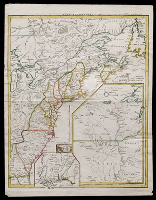
1755
Le Rouge, George L. (fl. 1755)
Canada et Louisiane [double page engraving with handcoloring]
Drawn by George Le Rouge, Engineer to the King. With hand-colored outlines. Double-page engraving showing the east coast of North America from New Foundland to Florida, with insets of Niagara Falls (small), New Orleans (medium) and upper Louisiana...
GLC05714
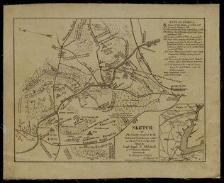
1861
Mitchell, Samuel P. (fl. 1861)
Sketch of the Country Occupied by the Federal & Confederate Armies on the 18th & 21st July 1861
Detailed map of the Battle of Manassas (Bull Run) showing roads, topographical features, troop positions, batteries, bridges, and railroads. Also has a legend of "Explanations." Pictures the battle field to the north of Manassas, with the Bull Run...
GLC05987.25
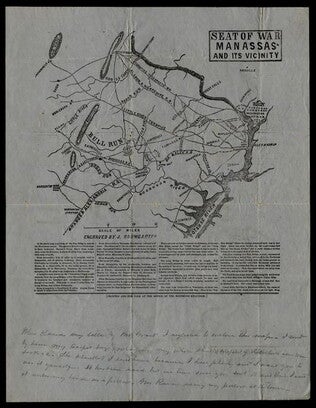
Baumgarten, J. (fl. 1861)
Seat of War Manassas and its Vicinity
Printed map detailing the battleground of 18 and 21 July 1861 at the Battle of First Manassas (Bull Run). Includes major roads and railroads, showing Washington D.C. on the right side. Contains descriptive text beneath the map. At the bottom is a...
GLC05987.26
Colton, J. H. (Joseph Hutchins) (1800-1893)
Colton's Plans Of U.S. Harbors Showing The Position & Vicinities Of The Most Important Fortifications On The Sea-Board And In The Interior. From U.S. Surveys and other authentic sources.
Printed and folded twenty one panel Civil War map marked "No. 5." Bound in a booklet listing major administration officials and generals on the inside cover, both Union and Confederate. Shows the Mississippi River from New Orleans to Cairo...
GLC06157.06
Showing results 11 - 15