Self-Paced Courses: Explore American history with top historians at your own time and pace!
24 August 1865
Unknown (1808-1875)
[Leather Valise/Pouch]
Lather valise/pouch contained a pardon for Payne and a transmittal envelope and letter. GLC00044.07.01-.03
GLC00044.07.04
1861
H.H. Lloyd & Co.
Lloyd's new political chart, 1861
Full title: "Lloyd's New Political Chart, 1861. With a Map of the United States, Showing the Free States, Border Slave States, Cotton States, and Territories, in Different Colors." Compiled and published by H.H. Lloyd & Co.'s Agents' General Depot...
GLC04243
November 1776
Sayer, Robert (fl. 1776)
The Theatre of war in North America [with:] A compendious account....
Not in Nebenzahl, Battle Plans of the American Revolution, but possibly related to 6 (?). With text "A Compendious Account of the British Colonies in North America" which contains a 1765 popluation chart of the British Colonies in North America...
GLC03285
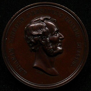
1871
U.S. Mint
[Medal of Abraham Lincoln to commemorate the Emancipation Proclamation]
Medal series of the U. S. Mint. Bronzed copper. High relief image of Lincoln based on Barber portrait. With words "Abraham Lincoln President of the United States." On verso, "Emancipation Proclaimed Jan. 1, 1863."
GLC08764
Unknown
Tag for Mayers' Furniture
GLC09400.611
1730
Seutter, Matthew
Recens Edita totius Novi Belgii [New Netherland - New York]
Matthew Seutter, following Jansson and Nicholas Visscher. Engraved map, handcolored. The map shows the back-and-forth tussle between the Dutch and English over New York and New Jersey, and uses both sets of place names. Cartouche shows New York...
GLC03583
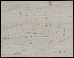
no date
Map of St. Augustine Harbor and Port
Map of St. Augustine Harbor and Port. San Sebastian River, North River, Matanzas River are pictured. Labels written in blue pen. Lighthouse Anastasia is labeled and drawn. Writing on verso specifies title of map.
GLC03974.40
circa 1840-1850
[Shackles]
These shackles resemble those used during the mid-1800s. Handwrought iron, consisting of two leg shackles linked by a flat iron plate. Could have been used for slaves, but also might have been used in a jailhouse for criminals.
GLC05338
circa February 1865
Aveleen, E. J. (fl. 1865)
[Manuscript Civil War map of the Confederate defenses around Sea Island, South Carolina]
Shows defenses between Secessionville and Fort Pringle, and down towards Forts Mahan and Delafield on Folly Island. James Island also appears. Shows the obstacles facing the Union's approach to Charleston, South Carolina in early 1865, including...
GLC06380
1856
Fremont, John Charles (1813-1890)
Free Soil, Free Speech, Free Press. Fremont. [Fremont & Dayton election ribbon]
White printed ribbon depciting Fremont as the explorer, mounted on a horse and pointing? to the left.
GLC05510
Showing results 1 - 10

![Recens Edita totius Novi Belgii [New Netherland - New York]](/sites/default/files/styles/site_search_thumbnail_2x/public/collection-images-th/GLC03583_th.jpg?itok=qY_Ka0As)