Self-Paced Courses: Explore American history with top historians at your own time and pace!
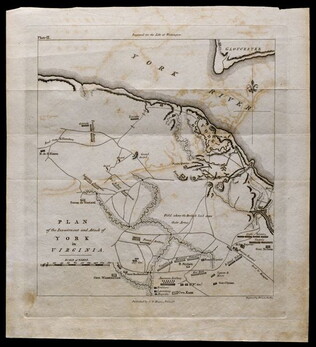
1781, reprint Philadelphia 1807
Plan of the investment and attack of York in Virginia [from Life of Washington]
Plate IX. Shows Yorktown. Published by C. P. Wayne; engraved by Francis Shallus.
GLC04760.02
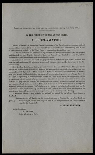
24 June 1865
Johnson, Andrew (1808-1875)
[Proclamation lifting restrictions on trade west of the Mississippi River]
Printed signature of President Johnson and Acting Secretary of State William Hunter. Proclamation will "restore unrestricted commercial intercourse between and in the several States ... and Territories west of the Mississippi river." Opens all trade...
GLC04973
7 September 1863
King & Baird (1839-1876)
The Road to Peace through Pennsylvania via Washington, as Engineered by Southern Rebels and their Democratic Allies.
Includes several excerpts from the Richmond Enquirer, described as Jefferson Davis' Organ. States that the next Congressional session will be important, as "During its deliberation, the Presidential campaign of 1864 will be marked out." Proposes...
GLC05645
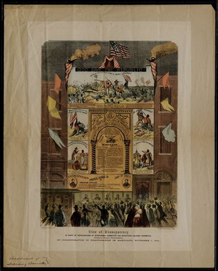
circa 1 November 1864
Ringwalt & Brown (fl. 1863-1865)
[Broadside regarding recruitment of African Americans and celebrating emancipation in Maryland]
Printed in commemoration of the adoption of emancipation in Maryland. The print incorporates five illustrations, three documenting African American combat valor and two related to emancipation and the future of African Americans. At the top of the...
GLC05701
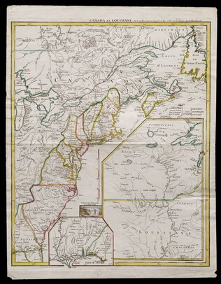
1755
Le Rouge, George L. (fl. 1755)
Canada et Louisiane [double page engraving with handcoloring]
Drawn by George Le Rouge, Engineer to the King. With hand-colored outlines. Double-page engraving showing the east coast of North America from New Foundland to Florida, with insets of Niagara Falls (small), New Orleans (medium) and upper Louisiana...
GLC05714
circa 1864
Unknown
A Traitor's Peace that the Northern Copperhead Leaders Would Force Upon the Country
Election broadside printed by McGill & Witherow in Washington D.C. for the Congressional Union Committee, with an engraving by Thomas Nast, from Harper's Magazine. Very similar to GLC06032 - same image and text, but different title (although, this...
GLC05986
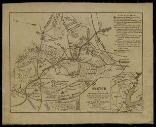
1861
Mitchell, Samuel P. (fl. 1861)
Sketch of the Country Occupied by the Federal & Confederate Armies on the 18th & 21st July 1861
Detailed map of the Battle of Manassas (Bull Run) showing roads, topographical features, troop positions, batteries, bridges, and railroads. Also has a legend of "Explanations." Pictures the battle field to the north of Manassas, with the Bull Run...
GLC05987.25
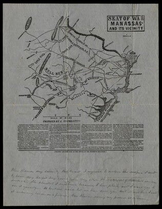
Baumgarten, J. (fl. 1861)
Seat of War Manassas and its Vicinity
Printed map detailing the battleground of 18 and 21 July 1861 at the Battle of First Manassas (Bull Run). Includes major roads and railroads, showing Washington D.C. on the right side. Contains descriptive text beneath the map. At the bottom is a...
GLC05987.26
[after 22 July 1861]
Anderson, T.J. (fl. 1861)
[Broadside announcing the First Battle of Manassas] Whig and Observer Extra
Headline states "Glorious News! From Virginia! The Battle of Manassas. Our Arm Victorious." The first excerpt, from the Columbus Republic Extra 21 July 1861, reports that General Pierre Gustave Toutant Beauregard's horse was shot from underneath him...
GLC05987.31
1864
The Degrading Compromise that the Northern Copperhead Leaders Would Force Upon the Country
Illustrated election broadside printed and circulated by the Indiana Union Club in Washington, D.C. The broadside is trying to influence the voters of Indiana to not vote for pro-Southern Copperheads. Top half of the broadside consists of an image...
GLC06032
Showing results 11 - 20