Self-Paced Courses: Explore American history with top historians at your own time and pace!
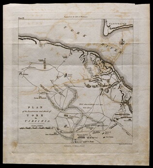
1781, reprint Philadelphia 1807
Plan of the investment and attack of York in Virginia [from Life of Washington]
Plate IX. Shows Yorktown. Published by C. P. Wayne; engraved by Francis Shallus.
GLC04760.02
Unknown
Upper-Silesian Plebiscite-Area
Final Results of the Plebiscite shown by districts.
GLC02766.009
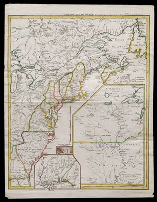
1755
Le Rouge, George L. (fl. 1755)
Canada et Louisiane [double page engraving with handcoloring]
Drawn by George Le Rouge, Engineer to the King. With hand-colored outlines. Double-page engraving showing the east coast of North America from New Foundland to Florida, with insets of Niagara Falls (small), New Orleans (medium) and upper Louisiana...
GLC05714
1847
M. Murguia
[Map of the part of the valley of Mexico which has been a field of battle]
Black-inked lithograph map of Mexico with route of armies in brown, blue and green inks. Denotes military travel during August and September of 1847. On back, note by Wellington Cleveland Burnett explaining locations. On front, cardinal directions...
GLC00155.02
17 August 1900
unkown
Upper Silesia Plebiscite Area
Shows area of developed mineral resources, including coal bearing area. Also includes railways and district boundaries. Red line for final British proposal, Blue for French, and Green for League of Nations lines.
GLC02766.003
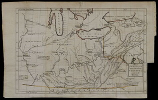
[1754]
Washington, George (1732-1799)
Map of the western parts of the colony of Virginia, as far as the Mississip[p]i
Rare folding map of Eastern part of what is today the United States to the Mississippi River. With orange color supplied on the borders of Virginia. Shows Washington's route from Williamsburg to French Fort. Removed from book due to condition 1997.
GLC00419.02
Showing results 131 - 136