Self-Paced Courses: Explore American history with top historians at your own time and pace!
1861
Bachmann, John (fl. 1849-1885)
Bird's-eye view of Texas and part of Mexico
From the series: Panorama of the Seat of War.
GLC03484
circa February 1782
Bauman, Sebastian (1739-1803)
Plan of the investment of York and Gloucester
Drafted at Washington's request, shortly after the battle of Yorktown, Virginia. Nebenzahl, Battle Plans of the American Revolution, 189, with references.
GLC01869
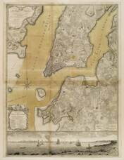
1776
Ratzer, Bernard
Plan of the City of New York in North America
Engraved by Jeffrey and Fagan. Oversize engraving showing lower Manhattan Island, part of Brooklyn and Hoboken, N.J. A cartouche extending across the bottom has a panoramic "South West View of the City of New York." Based upon the survey of 1766...
GLC02006
1730
Seutter, Matthew
Recens Edita totius Novi Belgii [New Netherland - New York]
Matthew Seutter, following Jansson and Nicholas Visscher. Engraved map, handcolored. The map shows the back-and-forth tussle between the Dutch and English over New York and New Jersey, and uses both sets of place names. Cartouche shows New York...
GLC03583
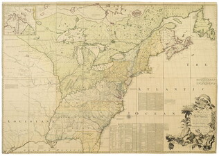
1755
Mitchell, John (fl. 1755)
Map of British & French Dominions in No. America [map used in Treaty of Paris]
Very large printed folded map with outline color. This is the "Treaty of Paris" map, third edition, the edition that was used in settling territorial claims in 1783. Accompanied by its original marbled-paper map case.
GLC03556
Showing results 1 - 5
![Recens Edita totius Novi Belgii [New Netherland - New York]](/sites/default/files/styles/site_search_thumbnail_2x/public/collection-images-th/GLC03583_th.jpg?itok=qY_Ka0As)