Self-Paced Courses: Explore American history with top historians at your own time and pace!
30 March 1774
Flucker, Thomas (1719-1783)
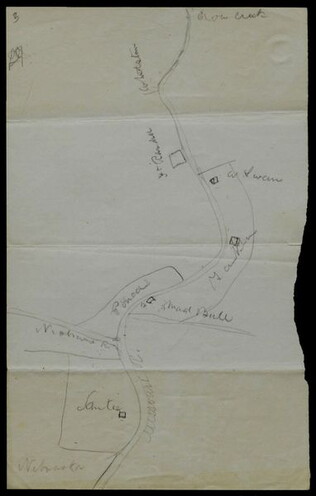
[Map of land]
A drawn map of land, likely located in Maine, deeded to Francis Waldo from Thomas and Hannah Flucker. Shows lakes, rivers, and boundary lines. Date taken from docket.
GLC02437.10645
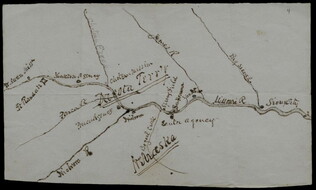
circa June 1872
Hemans, Daniel W. (fl. 1872-1881)
[Hand-drawn map of Dakota mission area]
Depicts the missions and Indian agencies along about fifty miles of the Missouri River west of Sioux City. Hemans discusses making the map for Frances Shiras to answer her question about the spatial relationship between the Santee, Yankton, and Ponca...
GLC02429.03
GLC02429.04
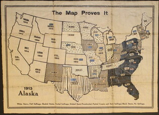
circa 1919
unknown, fl. 1919;
The Map Proves It [Women's suffrage map]
One map entitled "The Map Proves it" published circa 1919. This map illustrates the United States with different shading and colorizations of each state. The patterns and colors illustrate the status of the states in regards to women's suffrage...
GLC09773
18 December 1943
Polgar, Lillian (fl. 1943-)
homemade map to Lillian and Frank's house
Hand drawn and colored map to Lillian and Frank Polgar's house. On the left of the drawing there are notes that say housewarming, and fifth wedding anniversary.
GLC09414.1568
Showing results 1 - 5