Self-Paced Courses: Explore American history with top historians at your own time and pace!
1775
Montrésor, John (1736-1799)
A Plan of the City of New York & its environs
Actual title: "A Plan of the City of New-York & its environs..." Shows Manhattan Island up to Greenwich Village. Hand colored.
GLC04315
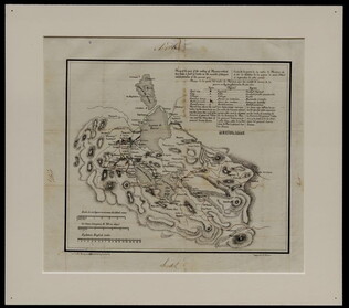
3 August 1781
Lincoln, Benjamin (1733-1810)
[Map of Charleston, South Carolina]
Manuscript map of Charleston, South Carolina showing the coastline, various rivers and geographic features, certain structures and county names. Date and creator inferred, based on the presumption that this map accompanies GLC02437.01112.
GLC02437.01113
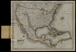
1846
J.H. Colton & Co.
Map of the United States, Mexico, and the West Indies, with parts adjoining
This document is a map of the United States, Mexico, and Caribbean territories belonging to George Cadwalader. Includes original holding case with "Cadwalader" inscription, which resembles a small book with a white binding ribbon. Map folds to 11.2 x...
GLC04577
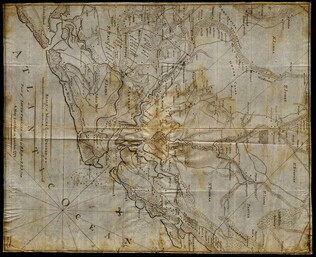
9 November 1812
Winchester, Marcus (fl. 1812-)
Map of Ohio
Manuscript map of the Ohio river environs, extending north into Canada, west to F. Recovery, south to Kentucky, and east to Pennsylvania.
GLC06997.018
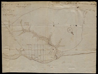
circa 1782
Erskine, Robert (1735-1780)
[Map of South Carolina]
A manuscript copy of a printed map of a portion of South Carolina. Shows lakes, rivers, streams, forest, towns, counties, and possibly roads. Noted, "Part of SOUTH CAROLINA copied by R. Erskine F. R. S. from A Map published in London 1771." Docket...
GLC02437.10611
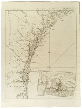
1780-1781
Barres, Joseph Frederick Wallet des (1722-1824)
The Atlantic Neptune [selected maps and charts]
GLC03103
October 1781
Unknown
[Map of Yorktown, Virginia]
Drawn map of Yorktown, Virginia. Shows roads, rivers, and other land markings, but not fortifications. With Cornwallis autograph note written across the front: "you will deliver the town immediately." Likely created by the British right before the...
GLC02437.10669
1787
Tarleton, Banastre
A History of the campaigns of 1780 and 1781, in the Southern Provinces
With Newberry Library bookplate and library stamp of the Newberry. Accompanied by William Eaton fold-out map (49 x 66 cm), showing Cornwallis' marches through Virginia and Maryland (while Jefferson was governor of Virginia).
GLC03667
1780
Untitled chart of the coast of Georgia and South Carolina [Savannah]
Includes small plan of the siege of Savannah in a cartouche.
GLC03103.15
18 December 1943
Polgar, Lillian (fl. 1943-)
homemade map to Lillian and Frank's house
Hand drawn and colored map to Lillian and Frank Polgar's house. On the left of the drawing there are notes that say housewarming, and fifth wedding anniversary.
GLC09414.1568
1755
Mitchell, John (fl. 1755)
Map of British & French Dominions in No. America [map used in Treaty of Paris]
Very large printed folded map with outline color. This is the "Treaty of Paris" map, third edition, the edition that was used in settling territorial claims in 1783. Accompanied by its original marbled-paper map case.
GLC03556
30 April 1941
Japan Cabinet Printing Bureau
General Map of Greater East Asian Co-prosperity Sphere and Pacific Ocean
Map of territories included in the Japanese propaganda concept, the "Greater East Asian Co-prosperity Sphere." The concept promoted the cultural and economic unity of the region by a self-sufficient bloc of Asian nations led by the Japanese and free...
GLC09552.11
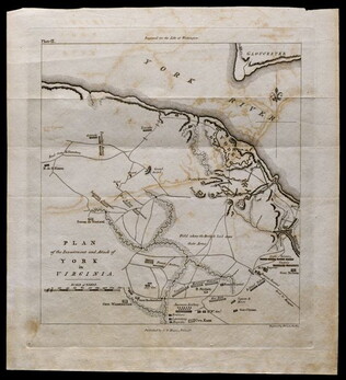
1781, reprint Philadelphia 1807
Plan of the investment and attack of York in Virginia [from Life of Washington]
Plate IX. Shows Yorktown. Published by C. P. Wayne; engraved by Francis Shallus.
GLC04760.02
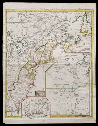
Le Rouge, George L. (fl. 1755)
Canada et Louisiane [double page engraving with handcoloring]
Drawn by George Le Rouge, Engineer to the King. With hand-colored outlines. Double-page engraving showing the east coast of North America from New Foundland to Florida, with insets of Niagara Falls (small), New Orleans (medium) and upper Louisiana...
GLC05714
Upper-Silesian Plebiscite-Area
Final Results of the Plebiscite shown by districts.
GLC02766.009
1847
M. Murguia
[Map of the part of the valley of Mexico which has been a field of battle]
Black-inked lithograph map of Mexico with route of armies in brown, blue and green inks. Denotes military travel during August and September of 1847. On back, note by Wellington Cleveland Burnett explaining locations. On front, cardinal directions...
GLC00155.02
17 August 1900
unkown
Upper Silesia Plebiscite Area
Shows area of developed mineral resources, including coal bearing area. Also includes railways and district boundaries. Red line for final British proposal, Blue for French, and Green for League of Nations lines.
GLC02766.003
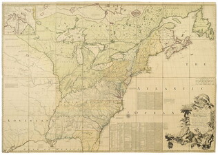
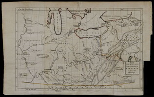
[1754]
Washington, George (1732-1799)
Map of the western parts of the colony of Virginia, as far as the Mississip[p]i
Rare folding map of Eastern part of what is today the United States to the Mississippi River. With orange color supplied on the borders of Virginia. Shows Washington's route from Williamsburg to French Fort. Removed from book due to condition 1997.
GLC00419.02
Showing results 176 - 193