Self-Paced Courses: Explore American history with top historians at your own time and pace!
1792
Ellicott, Andrew (fl. 1792)
[Map of Washington, D.C.].
Engraved folding map removed from the "Columbian Magazine." Included with a letter from Thomas Jefferson to Charles W. Dumas (GLC07104.01).
GLC07104.02
1784 circa
Pico, Joshua (fl. 1760-1790)
[Liquor merchant's trunk]
Belonged to Joshua Pico, a liquor merchant from Boston. Wooden chest with two handles, metal edges, and a lock on the lid. The key is missing so the lock is stuffed with paper to prevent locking. Interior has separated compartments for six large...
GLC01450.911
1784
Hills, John (fl. 1771-1796)
Sketch of the position of the British forces at Elizabeth-Town Point
Original by John Hill. Oversize engraved map with hand coloring of troop positions. Engraved by Faden. Nebenzahl, Battle Plans of the American Revolution, 146.
GLC01858
9 December 1801
Gleason, John (fl. 1796-1811)
[Copy of a survey map of land sold by Henry Knox to B. Joy of Boston]
Gleason and Robert Houston sign as surveyors. Depicts 16,340 acres of Waldo Patent land flanked by these notations: "Green, Waldo Heirs, Knox, Belfast, Northport, Lincolnville, and Bonapartte." A list of names is written in pencil within the area...
GLC02437.10341
23 July -6 August 1784
Galbraith, P. Bartrem (fl. 1784)
[Map of the Susquehanna River]
Drawn map of a portion of the Susquehanna River, with creeks, forts, and ferry landings noted. Also includes the distances to various points on the map. Noted as drawn above Canawago Falls, which is in Pennsylvania.
GLC02437.10583
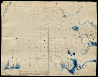
Pierpont, Joseph (fl. 1792)
[Map of land]
Map of the land by the Penobscot River. Water is drawn with blue watercolor ink. Shows the division of land into different plots.
GLC02437.10593
1795
Map of surveyed land possibly located in Maine. Titled, "THE SOUTH LINE OF the 50000 Acres Run By John Gleason Junr 1795 No 1." Covers three miles and a half of land and includes notes on the quality of land. Document is partially printed with...
GLC02437.10598
circa 1796-1806
A sketch of land surveyed by John Gleason. Cover 50,000 acres of land likely located in Maine. Shows a pond and various land marks in water colors and has a partially colored border.
GLC02437.10650
circa 1784-1806
Unknown
A drawn map of lands near the Penobscot River in Maine. Land is noted as belonging to the heirs of Brigadier [General Samuel] Waldo. Lakes and rivers are noted in blue water color. Includes a drawn compass showing cardinal directions.
GLC02437.10652
circa 1790
Noted as a copy. Drawn sketch of a plan for the northwestern part of the Waldo Patent located in Maine. Depicts county lines and the northern and western boundaries of the Waldo Patent. Date was added later in pencil.
GLC02437.10666
no date
Map from Stratford to Poughkeepsie
This printed map appears to be cut out of a larger book or atlas. Neither Stratford nor Poughkeepsie is on the map. Has slight water damage/staining.
GLC02437.08401
1801 ca.
[Jefferson Indian Peace medal]
Based on Houdon's bust of Jefferson. Copies of this medal were given by Lewis and Clark to Indians they met on their expedition. See Alfred L. Bush, Life Portraits of Thomas Jefferson, p. 13; Noble E. Cunningham, Jr., The Image of Thomas Jefferson in...
GLC01984.03
1792-1793 ca.
Jefferson, Thomas (1743-1826)
Collateral to US Mint: Rittenhouse medal, one-cent & half-cent coins with prints
Collateral items: print of Jefferson; a photo, "Ye Old Mint;" a print titled "The Coin Room;" a commemorative medal with the words "David Rittenhouse 1st Director U.S. Mint;" a one cent coin with a flowing hair liberty on the front and chain link on...
GLC01997.02
1792 circa
Untitled
1 metal, 1 cent coin, 1/2 cent coin. 1 cent coin is known as a flowing hair, wreath penny from 1793, the second US coin minted.
GLC01999.02
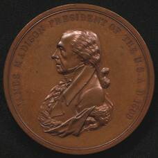
1809
Reich, John (fl. 1809)
[James Madison Indian peace medal]
Medal features James Madison's profile on front and the words "James Madison President of the U.S. A.D. 1809." Designer is unknown. Verso features two hands shaking, a tomahawk crossed with a pipe, and the words, "Peace and Friendship," designed by...
GLC02767.02
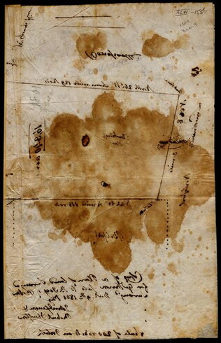
circa November 1813
Gwinnett, Button (ca. 1735-1777)
[Map of Button Gwinnett's estate]
Hand sketched map of Gwinnett's estate in Georgia of 1450 acres showing the bordering properties. Mentions neighboring properties of James Spalding and Mary Maxwell. Circa date from typed label originally accompanying the document upon acquisition.
GLC00658.02
Duvivier, Benjamin (1728-1819)
[Medal of George Washington Before Boston]
The inscription on recto, around a bust portrait of George Washington (based on Houdon) reads in Latin: "George Washington Supremo Duci exercituum adsertori libertatis. Comitia Americana." The verso shows Washington and his officers looking towards...
GLC03221
1787
Tarleton, Banastre
A History of the campaigns of 1780 and 1781, in the Southern Provinces
With Newberry Library bookplate and library stamp of the Newberry. Accompanied by William Eaton fold-out map (49 x 66 cm), showing Cornwallis' marches through Virginia and Maryland (while Jefferson was governor of Virginia).
GLC03667
[rudimentary map of John Jackson's estate]
backside contains figures
GLC03769.008
1794/05/14
Whittle & Laurie
A new and general map of the middle dominion belonging to the United States...
The map shows part of the United States, from western New England to Michigan, and from Vermont to southern Virginia.
GLC04178
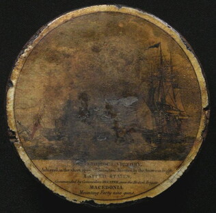
circa 1812
[War of 1812 lacquer snuffbox showing victory of United States over Macedonian]
Cylindrical, varnished snuff box from the War of 1812. Lid commemorates the 25 October 1812 capture of the British ship Macedonia by the USS United States, commanded by Stephen Decatur. Bottom depicts the bald eagle seal of the United States...
GLC04750
Faden, William (ca. 1750-1836)
Plan of the Siege of Savannah...
Nebenzahl, Battle Plans of the American Revolution, 76.
GLC04316
1796/01/01
Arrowsmith, Aaron (fl. 1796)
A Map of the United States of North America
Handcolored. Each sheet is 66 cm high. The map shows the northwest territory outside the Union. A portion of Louisiana is included.
GLC04318
1786/08/15
Sayer, Robert
A Map of the Whole Continent of America... [Wall Map on 4 sheets]
GLC04412.01
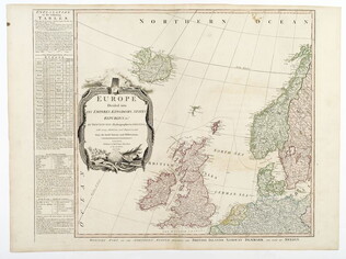
1787/01/01
Europe divided into its Empires, Kingdoms, States... [Wall Map on 4 sheets]
This map has an attractive depiction of Algiers and the Barbery states which is slightly larger than that for GLC# 4412.04 (Africa)
GLC04412.02
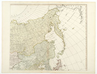
1787/01/06
Asia and its islands, according to D'Anville... [Wall Map on 4 sheets]
GLC04412.03
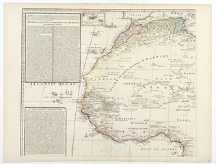
Africa with all its states, kingdoms... by S. Boulton [Wall Map on 4 sheets]
GLC04412.04
circa 1800
[Slave shackles intended for a child]
Circa date previously estimated. Consists of two loops held together by a metal pin. Shackles were intended for a child.
GLC06151
1794? ca.
Paine, Thomas
British "Conder" halfpenny token expressing anger against Thomas Paine
Recto: "End of Pain" [sic] with depiction of a figure hanging from a scaffold. Verso: "May the knave of Jacobin clubs never get a trick."
GLC06303
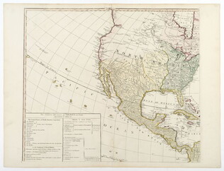
1810
Arrowsmith, Aaron
A new map of Mexico and adjacent provinces [roll map on linen]
A New Map of Mexico and Adjacent Provinces Compiled from Original Documents.... London: Published 5th. October 1810, by A. Arrowsmith, 10 Soho Sque. Hydrographer to His Majesty, 1810. Wall map, mounted on linen, with wooden rollers at top and bottom...
GLC06091
circa 1783
Vose, Joseph (1738?-1816)
[Society of Cincinnati gold enameled eagle medallion with 2 cuff links]
Accompanied by blue and white shirt cuff buttons or links.
GLC05849
1804/09/28
Krafft, C. de (fl. 1804)
A View of Tripoli in Barbary
GLC07828
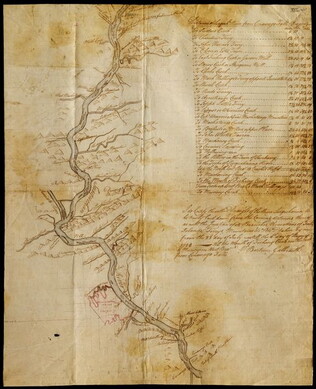
9 November 1812
Winchester, Marcus (fl. 1812-)
Map of Ohio
Manuscript map of the Ohio river environs, extending north into Canada, west to F. Recovery, south to Kentucky, and east to Pennsylvania.
GLC06997.018
1680-1800
[Middle Passage iron bilboes, 18th century]
One set of middle passage iron bilboes, circa 1680-1800. Item is an iron restraint for ankles or wrists used on slave ships to fasten two enslaved people to each other. Consist of an iron bar running through two c-shaped cuffs. One end of the rod has...
GLC09707
A Map of Africa, From the best Authorities
One map entitled A Map of Africa, From the best Authorities, dated 1810. Contains the entire continent of Africa, as well as a small portion of the Middle East. The island of Madagascar is also included. The map notes many coastal cities, as well as...
GLC09862.03
Showing results 1 - 35