Self-Paced Courses: Explore American history with top historians at your own time and pace!
1824
Cooper, Thomas, (1805-1892)
Correspondence between George Hibbert Esq., and the Rev. T Cooper relative to the condition of The Negro Slaves in Jamaica...Also a Libel on the Character of Mr. and Mrs. Cooper
JB00460
1890
Bien, Julius, (fl. 1890)
Proportion of the Colored to the Aggregate Population: 1890
JB00597
Salmon, Thomas
[Map of Africa]
A map of Africa with a small engraving of a crocodile and a fort on the lower left corner.
JB00030
John Tallis & Company
Western Africa
JB00101
The Growth and Development of America in Maps
GLC09861
7 engraved maps of Africa
GLC09862
Ornamental Map of the United States and Mexico
GLC09863
1689
Nolin, I.B. (fl. 1689)
L'Amerique Septentrionale, ou la Partie Septentrionale des Indes Occidentales
One map entitled "L'Amerique Septrentrionale, ou la Partie Septentrionale des Indes Occidentales," dated 1689. Illustrated by I.B. Nolin. Item is a reduced map of North America and the West Indies. Also noted is California as an island. The original...
GLC09864
WWII Newsmap published by the War Department Bureau of Public Relations
GLC09865
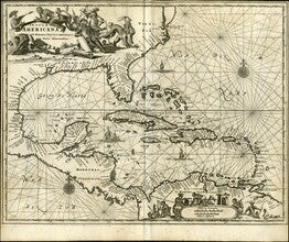
1671
Montanus, (fl. 1670-1671)
Insulae Americanae in Oceeano Septentrionali cum Terris adiacenibus [Map of the Americas]
A map entitled, "Insulae Americanae in Oceano Septentrionali cum Terris adiacenibus" dated circa 1671. The map features Florida, the Gulf of Mexico, Cuba, the island of Espanolia which is modern day Haiti and Dominican Republic, Jamacia, Puerto Rico...
GLC09789
Showing results 261 - 270