Self-Paced Courses: Explore American history with top historians at your own time and pace!
1792
Ellicott, Andrew (fl. 1792)
[Map of Washington, D.C.].
Engraved folding map removed from the "Columbian Magazine." Included with a letter from Thomas Jefferson to Charles W. Dumas (GLC07104.01).
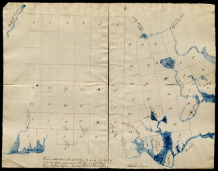
GLC07104.02
Pierpont, Joseph (fl. 1792)
[Map of land]
Map of the land by the Penobscot River. Water is drawn with blue watercolor ink. Shows the division of land into different plots.
GLC02437.10593
1795
Gleason, John (fl. 1796-1811)
Map of surveyed land possibly located in Maine. Titled, "THE SOUTH LINE OF the 50000 Acres Run By John Gleason Junr 1795 No 1." Covers three miles and a half of land and includes notes on the quality of land. Document is partially printed with...
GLC02437.10598
circa 1796-1806
A sketch of land surveyed by John Gleason. Cover 50,000 acres of land likely located in Maine. Shows a pond and various land marks in water colors and has a partially colored border.
GLC02437.10650
circa 1790
Unknown
Noted as a copy. Drawn sketch of a plan for the northwestern part of the Waldo Patent located in Maine. Depicts county lines and the northern and western boundaries of the Waldo Patent. Date was added later in pencil.
GLC02437.10666
1794/05/14
Whittle & Laurie
A new and general map of the middle dominion belonging to the United States...
The map shows part of the United States, from western New England to Michigan, and from Vermont to southern Virginia.
GLC04178
1796/01/01
Arrowsmith, Aaron (fl. 1796)
A Map of the United States of North America
Handcolored. Each sheet is 66 cm high. The map shows the northwest territory outside the Union. A portion of Louisiana is included.
GLC04318
Showing results 1 - 7