Self-Paced Courses: Explore American history with top historians at your own time and pace!
30 March 1774
Flucker, Thomas (1719-1783)
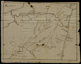
[Map of land]
A drawn map of land, likely located in Maine, deeded to Francis Waldo from Thomas and Hannah Flucker. Shows lakes, rivers, and boundary lines. Date taken from docket.
GLC02437.10645
circa 1775
Montrésor, John (1736-1799)
[Two wall maps of the province of New York and surrounding areas] [Decimalized]
GLC03101
Montrésor, John (1736-1799)
[Map of Lower New York State and surrounding areas]
Full title "To the Right Honourable Sir Jeffrey Amherst Knight of the Bath and Lieutenant General of his Majesty's forces etc., This map of the Province of New York is humbly Inscribed by His most obliged humble servant John Montresor, Engineer."...
GLC03101.02
10 January 1774
Dunn, Samuel (fl. 1774)
North America as divided amongst the European powers
From The American Military Pocket Atlas (London, 1776), used by the British forces in the American Revolutionary War. "39" written on top right and bottom right corner of map. Reference numbers: Lowery 563. Phillips, Atlases 1206.
GLC02373
[1768/11]
Unknown
Indian Boundary Line as Settled by Sr. William & them in Nov[ember[ 1768
GLC03107.02166
Showing results 1 - 5