Self-Paced Courses: Explore American history with top historians at your own time and pace!
1775
Montrésor, John (1736-1799)
A Plan of the City of New York & its environs
Actual title: "A Plan of the City of New-York & its environs..." Shows Manhattan Island up to Greenwich Village. Hand colored.
GLC04315
1776/06/28
Faden, William (ca. 1750-1836)
A Plan of the Attack on Fort Sulivan [Sullivan]... 28th of June 1776
Nebenzahl, Battle Plans of the American Revolution, 64.
GLC04317
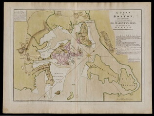
1776/03/12
Dury, Andrew (fl. 1776)
A Plan of Boston and its Environs... [siege of Boston]
Nebenzahl, Battle Plans of the American Revolution, 16.
GLC04410
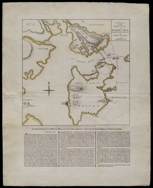
1775/11/27
Sayer, Robert
A Plan of the Battle on Bunkers Hill [Boston]
Nebenzahl, Battle Plans of the American Revolution, 28.
GLC04411
1777/06/17
Kitchin, Thomas (fl. 1777)
British dominions in America agreeable to the treaty of 1763...
With hand-colored outlines. Depicts the east coast of North America from New Foundland to Florida. Printed by Dury.
GLC05713
1770
Rollos, George, (fl. 1770)
An Accurate Map of Africa Drawn from the Sieur Robert with Improvements
One map entitled An Accurate Map of Africa Drawn from the Sieur Robert with Improvements, dated 1770. Contains the entire continent of Africa, as well as a small portion of the Middle East. The island of Madagascar is also included. The map notes...
GLC09862.02
Showing results 51 - 56