Self-Paced Courses: Explore American history with top historians at your own time and pace!
1856 ca.
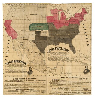
To the free men of the North [election] [large cloth-backed lithographed map]
Free Labor Party abolitionist map used during the 1856 presidential campaign, printed, with hand-coloring in red, black and green.
GLC06662
circa 1852
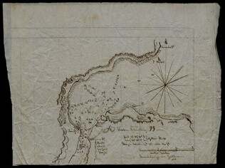
[Slave Trade Map]
Depicting infamous African slave port of Lindi at the mouth of the Lindi River, terminus of East African Arab slave route.
GLC08363
1815-1860
Unknown
[Map of Sanders property given to Joshua Sanders]
GLC09302.007
1730
Seutter, Matthew
Recens Edita totius Novi Belgii [New Netherland - New York]
Matthew Seutter, following Jansson and Nicholas Visscher. Engraved map, handcolored. The map shows the back-and-forth tussle between the Dutch and English over New York and New Jersey, and uses both sets of place names. Cartouche shows New York...
GLC03583
1861
H.H. Lloyd & Co.
Lloyd's new political chart, 1861
Full title: "Lloyd's New Political Chart, 1861. With a Map of the United States, Showing the Free States, Border Slave States, Cotton States, and Territories, in Different Colors." Compiled and published by H.H. Lloyd & Co.'s Agents' General Depot...
GLC04243
Showing results 1 - 5
![Recens Edita totius Novi Belgii [New Netherland - New York]](/sites/default/files/styles/site_search_thumbnail_2x/public/collection-images-th/GLC03583_th.jpg?itok=qY_Ka0As)