MA in American History: Apply now and enroll in graduate courses with top historians this summer!
1777/06/17
Kitchin, Thomas (fl. 1777)
British dominions in America agreeable to the treaty of 1763...
With hand-colored outlines. Depicts the east coast of North America from New Foundland to Florida. Printed by Dury.
GLC05713
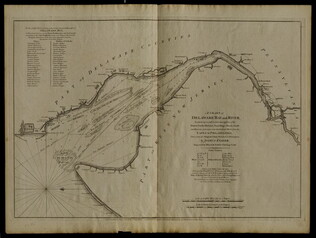
12 March 1776
Faden, William (ca. 1750-1836)
A Chart of Delaware Bay and River
Chart by Joshua Fisher. Depicts areas of Western New Jersey, Delaware, and Pennsylvania. There is extra shading on the shorelines of these states. Engraved by William Faden. Includes list of river pliots who subscribed to have it published. Slight...
GLC05237
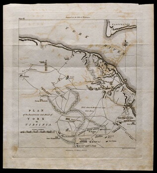
1781, reprint Philadelphia 1807
Plan of the investment and attack of York in Virginia [from Life of Washington]
Plate IX. Shows Yorktown. Published by C. P. Wayne; engraved by Francis Shallus.
GLC04760.02
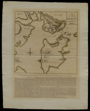
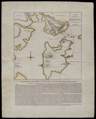
27 November 1775
Sayer, Robert
A Plan of the Battle on Bunkers Hill fought on the 17th of June 1775.
This document is a printed map of the Battle of Bunker Hill, designating the positions of American and British forces. Printed by R. Sayer and J. Bennet. Underneath the map is a written description of the Battle taken from a letter written by General...
GLC04760.01
1775/11/27
A Plan of the Battle on Bunkers Hill [Boston]
Nebenzahl, Battle Plans of the American Revolution, 28.
GLC04411
Showing results 1 - 5