MA in American History: Apply now and enroll in graduate courses with top historians this summer!
circa 1775-1776
Unknown
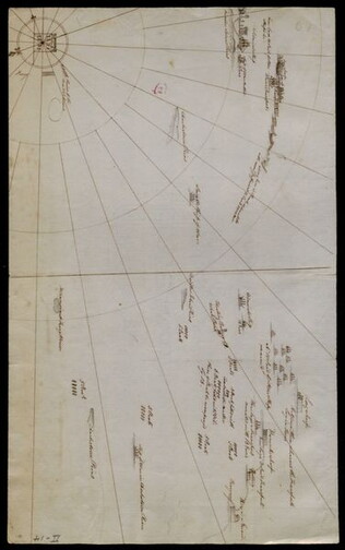
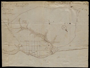
[Battle plan for the siege of Boston Harbor]
Mapped battle plan for an American siege of Boston Harbor. Shows boats and some major geographic markers. For written plans see GLC02437.00231.
GLC02437.00232
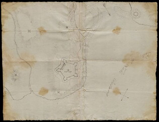
3 August 1781
Lincoln, Benjamin (1733-1810)
[Map of Charleston, South Carolina]
Manuscript map of Charleston, South Carolina showing the coastline, various rivers and geographic features, certain structures and county names. Date and creator inferred, based on the presumption that this map accompanies GLC02437.01112.
GLC02437.01113
circa 1782-1783
Bauman, Sebastian (1739-1803)
[Map of Forts Ontario and Oswego and surroundings]
Docketed as "A rough sketch of Oswego by Major Bauman." Shows Fort Ontario (captioned), Fort Oswego (uncaptioned) and surrounding features (possibly earthworks).
GLC02437.10667
30 March 1774
Flucker, Thomas (1719-1783)
[Map of land]
A drawn map of land, likely located in Maine, deeded to Francis Waldo from Thomas and Hannah Flucker. Shows lakes, rivers, and boundary lines. Date taken from docket.
GLC02437.10645
circa 1775
Montrésor, John (1736-1799)
[Map of Lower New York State and surrounding areas]
Full title "To the Right Honourable Sir Jeffrey Amherst Knight of the Bath and Lieutenant General of his Majesty's forces etc., This map of the Province of New York is humbly Inscribed by His most obliged humble servant John Montresor, Engineer."...
GLC03101.02
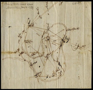
8 January 1777
[Map of roads in the vicinity of Morristown, New Jersey]
Indicates roads, some natural features, landmarks ("court house," "Whites Tavern Genl Lees," bridge, landing, etc.), outlying towns, and distance between points on the map. Indicates the location of towns surrounding Morristown. Notes the position...
GLC02437.09543
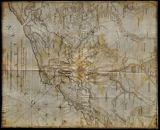
circa 1782
Erskine, Robert (1735-1780)
[Map of South Carolina]
A manuscript copy of a printed map of a portion of South Carolina. Shows lakes, rivers, streams, forest, towns, counties, and possibly roads. Noted, "Part of SOUTH CAROLINA copied by R. Erskine F. R. S. from A Map published in London 1771." Docket...
GLC02437.10611
October 1781
[Map of Yorktown, Virginia]
Drawn map of Yorktown, Virginia. Shows roads, rivers, and other land markings, but not fortifications. With Cornwallis autograph note written across the front: "you will deliver the town immediately." Likely created by the British right before the...
GLC02437.10669
4 July 1781
Storers, Christain (fl. 1781)
[Sketch of land]
Charles Miller signed the docket on 2 November 1801. A sketch of Christian Storers' surveyed land lying in "Waldowborough" [Waldoborough, Maine]. Includes written information regarding boundary lines and a drawn compass showing cardinal directions...
GLC02437.10646
Montrésor, John (1736-1799)
[Two wall maps of the province of New York and surrounding areas] [Decimalized]
GLC03101
Showing results 1 - 10