Self-Paced Courses: Explore American history with top historians at your own time and pace!
1777/06/17
Kitchin, Thomas (fl. 1777)
British dominions in America agreeable to the treaty of 1763...
With hand-colored outlines. Depicts the east coast of North America from New Foundland to Florida. Printed by Dury.
GLC05713
1884
Royce, C. C.
Map of the former territorial limits of the Cherokee Nation of Indians
From the Fifth Annual Report printed by N. Peters. (Map printed by C.C. Royce.)
GLC05689
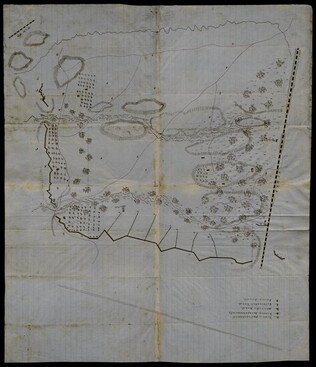
May 1862
Unknown
[Confederate Civil War map of the Army of Mississippi camp at Corinth, Mississippi]
Manuscript map shows the lines of entrenchments and reinforcements, the Danville Road, cultivated land, camp roads, a cotton press, the O & M Railroad and C & M Railroad, and General William J. Hardee's headquarters. Map was blind stamped while...
GLC05668
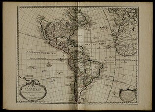
1722
De L'Isle, Guillaume (fl. 1718-1722)
Carte d'Amerique
Mercator projection including North and South America, with parts of Western Europe and Africa. Boundaries outlined in color. Shows North America from French perspective with English colonies restricted to the coast. Includes latitude and longitude...
GLC05238
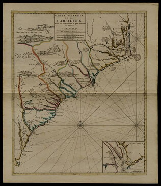
circa 1696
Sanson, Nicholas (1600-1667)
Carte generale de la Caroline dresse sur les memoirs le plus nouveaux
Map of North and South Carolina in an early period of settlement. Includes an inset of the area around Charleston, which locates plantations. This copy has a pencil note "1740" in margin, but no evidence for dating. In fact, this map remained...
GLC05236
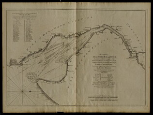
12 March 1776
Faden, William (ca. 1750-1836)
A Chart of Delaware Bay and River
Chart by Joshua Fisher. Depicts areas of Western New Jersey, Delaware, and Pennsylvania. There is extra shading on the shorelines of these states. Engraved by William Faden. Includes list of river pliots who subscribed to have it published. Slight...
GLC05237
1845
Frémont, John C. (1813-1890)
Map of the exploring expedition to the Rocky Mountains in the year 1842, and to Oregon and north California in the years 1843-'44
Lithograph by E. Weber & Co. of Baltimore, Maryland. Map part of Frémont's "Report of the exploring expedition to the Rocky Mountains in the year 1842, and to Oregon and north California in the years 1843-'44" (see GLC05103.01). Outlines Frémont's...
GLC05103.02
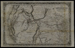
1852
Horn, Hosea B. (fl. 1852)
Map to Illustrate Horn's Overland Guide to California and Oregon
Map originally attached to Horn's overland guide (housed with books, GLC 4152.01), from the U.S. Indian sub-agency, Council Bluffs, on the Missouri River, to the City of Sacramento, in California containing a table of distances, and showing all the...
GLC04152.02
8 October 1864
Stephens, Asbury L. (b. 1843)
[Manuscript Civil War map of the position of an army division at the Ogeecheee River in Georgia]
Shows the position of the 4th Division of the 15th Army Corps, the road to Savannah, the Confederate lines across the swamp. Also shows positions of various troops and General William T. Sherman's headquarters. Drawn in brown and pink ink a month...
GLC04498.05
February 1865
[Manuscript Civil War map of the siege of Columbia, South Carolina]
Circular map showing the position of the 4th Division of the 13th Army Corps, rivers, railroads, and roads around Columbia. General Sherman's siege was on 16-17 February 1865. Drawn in brown and pink ink.
GLC04498.06
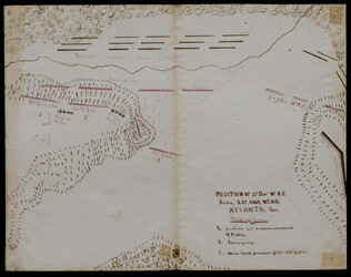
22 July 1864
[Manuscript Civil War map of the position of the 2nd Division, 16th Army Corps in the Battle of Atlanta]
Shows the Confederate line, the positions of Union brigades, and a skirmish in the Battle of Atlanta. The legend indicates the positions at the beginning of the battle, the charging that occurred ("Rebel line charging") and the new line that was...
GLC04498.02
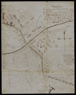
27 July 1864
Snell, J.P. (fl. 1864)
[Manuscript Civil War map of the Battle of Atlanta]
Presented by Snell to Asbury Stephens, "one of the participants this 23d. day of Sept. 1864, at Eastpoint, Ga." Shows where the 2nd Brigade crossed the railroad, moved into battle, position at the works, and its efforts to repulse the Confederates...
GLC04498.03
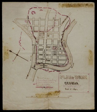
[Manuscript Civil War map of the Plan of Rome, Floyd County, Georgia]
Shows the locations of fortifications, a steam boat landing, and troop positions. Made two days before General Hood's army skirmished with General Sherman's supply line near Rome, causing Sherman's forces to fortify themselves in the town. Colored...
GLC04498.04
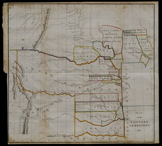
20 May 1834
United States. Congress. House.
Map of the Western Territory & c.
Large folding map of present-day Oklahoma with borders outlined in watercolour designating areas occupied by Native American tribes. Map was previously bound in back of the House Report found in 4132.01. Border lines are colored in blue, yellow...
GLC04132.02
1862
Abbot, Henry L. (1831-1927)
Campaign Map Army of the Potomac, Map No. 3. White House to Harrisons Landing
"Prepared by Command of Maj. Gen. George B. Mc.Clellan U.S.A. Commanding Army of the Potomac Brig. Gen. A.A. Humphreys Chief of Top. Engrs Army of the Potomac." Print engraved by W.H. Dougal. Map compiled by Abbot.
GLC04355.06
Campaign Maps Army of the Potomac, Map No. 2. Williamsburg to White House
Title continues: "Prepared by Command of Maj. Gen. George B. Mc.Clellan U.S.A. Commd'g Army of the Potomac A.A. Humphreys Brig. Gen. and Chief of Top. Engr's. Photographed at the Coast Survey Office. A faint brown-line print on four pieces of joined...
GLC04355.07
GLC04355.08
Campaign Maps Army of the Potomac, Map No. 1. Yorktown to Williamsburg
Title continues: "Prepared by Command of Maj. Gen. George B. Mc.Clellan U.S.A. Commanding Army of the Potomac Brig. Gen. A.A. Humphreys Chief of Top. Engrs Army of the Potomac." Engraved by W.H. Dougal. Map compiled by Abbot. Printed version of...
GLC04355.03
GLC04355.04
Title continues: "Prepared by Command of Maj. Gen. George B. Mc.Clellan U.S.A. Commd'g Army of the Potomac A.A. Humphreys Brig. Gen. and Chief of Top. Engr's." Map compiled by Abbot. Photographed at the Coast Survey Office. A very faint brown-line...
GLC04355.05
Campaign Maps Army of the Potomac, Map No. 1. Yorktown to Williamsburg [Manuscript map signed]
Title continues: "Prepared by Command of Maj. Gen. George B. Mc.Clellan U.S.A. Commd'g Army of the Potomac A.A. Humphreys Brig. Gen. and Chief of Top. Engr's." Accomplished on four pieces on joined wove paper. Photographed at the Coast Survey Office...
GLC04355.02
20 March 1862
Worret, Charles (b. 1819)
[Manuscript map, Military Reconnaissance Dept. Va]
Title continues: "Major Genl. Wool Comdg. Drawn by Sergt. Worret & Compiled Under the Direction of Colonel T.J. Cram Chief Topl. Engr. Dept. Va." "Copy." Shows the Yorktown Peninsula and contains a description of the area in terms of its potential...
GLC04355.01
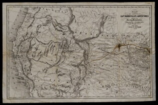
1856
Colton, J. H. (Joseph Hutchins) (1800-1893)
Map to illustrate Capt. Bonneville's adventures among the Rocky Mountains.
The map covers the western United States, with Washington, Oregon, California, Utah, New Mexico, Nebraska, Kansas, Texas, and Arkansas. Published in New York by George P. Putnam. Owned by John Moore (1826-1907), an army surgeon with the Utah...
GLC04194.01
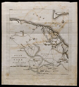
1781, reprint Philadelphia 1807
Plan of the investment and attack of York in Virginia [from Life of Washington]
Plate IX. Shows Yorktown. Published by C. P. Wayne; engraved by Francis Shallus.
GLC04760.02
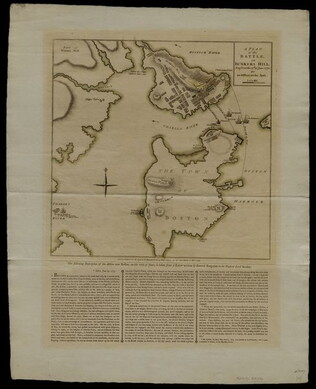
27 November 1775
Sayer, Robert
A Plan of the Battle on Bunkers Hill fought on the 17th of June 1775.
This document is a printed map of the Battle of Bunker Hill, designating the positions of American and British forces. Printed by R. Sayer and J. Bennet. Underneath the map is a written description of the Battle taken from a letter written by General...
GLC04760.01
Showing results 26 - 50