MA in American History: Apply now and enroll in graduate courses with top historians this summer!
1777/06/17
Kitchin, Thomas (fl. 1777)
British dominions in America agreeable to the treaty of 1763...
With hand-colored outlines. Depicts the east coast of North America from New Foundland to Florida. Printed by Dury.
GLC05713
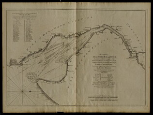
12 March 1776
Faden, William (ca. 1750-1836)
A Chart of Delaware Bay and River
Chart by Joshua Fisher. Depicts areas of Western New Jersey, Delaware, and Pennsylvania. There is extra shading on the shorelines of these states. Engraved by William Faden. Includes list of river pliots who subscribed to have it published. Slight...
GLC05237
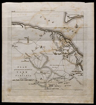
1781, reprint Philadelphia 1807
Plan of the investment and attack of York in Virginia [from Life of Washington]
Plate IX. Shows Yorktown. Published by C. P. Wayne; engraved by Francis Shallus.
GLC04760.02
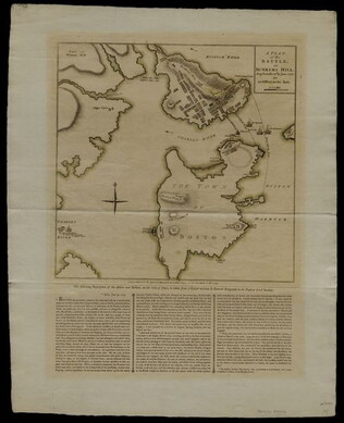
27 November 1775
Sayer, Robert
A Plan of the Battle on Bunkers Hill fought on the 17th of June 1775.
This document is a printed map of the Battle of Bunker Hill, designating the positions of American and British forces. Printed by R. Sayer and J. Bennet. Underneath the map is a written description of the Battle taken from a letter written by General...
GLC04760.01
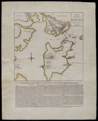
1775/11/27
A Plan of the Battle on Bunkers Hill [Boston]
Nebenzahl, Battle Plans of the American Revolution, 28.
GLC04411
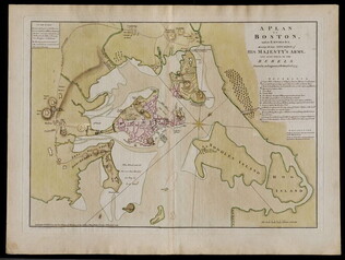
1776/03/12
Dury, Andrew (fl. 1776)
A Plan of Boston and its Environs... [siege of Boston]
Nebenzahl, Battle Plans of the American Revolution, 16.
GLC04410
1776/06/28
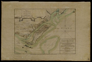
A Plan of the Attack on Fort Sulivan [Sullivan]... 28th of June 1776
Nebenzahl, Battle Plans of the American Revolution, 64.
GLC04317
1775
Montrésor, John (1736-1799)
A Plan of the City of New York & its environs
Actual title: "A Plan of the City of New-York & its environs..." Shows Manhattan Island up to Greenwich Village. Hand colored.
GLC04315
01 July 1778
British camp at Trudruffrin [Penna.] from the 18th to the 21st of September 1777...
title continues: "...with the attack made by Major General Grey against the rebels near White Horse Tavern, on the 20th of September. Drawn by an Officer on the Spot." Engraved and Published by W. Faden. Depicts the positions of various regiments and...
GLC04312
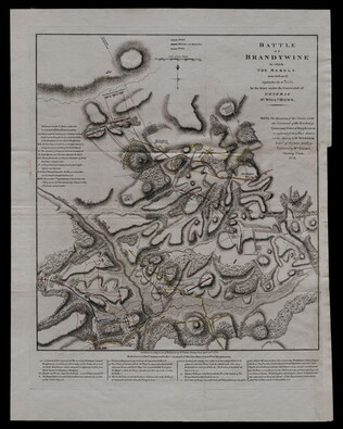
1778/04/13
Battle of Brandywine...rebels were defeated, September 11th, 1777...
Nebenzahl, Battle Plans of the American Revolution, 126; British Library 123; Clemonts catalog 14, Snyder fig. 185.
GLC04313
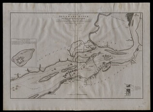
1777
The Course of Delaware River from Philadelphia to Chester....
Nebenzahl, Battle Plans of the American Revolution, 132.
GLC04303
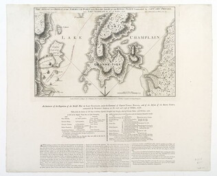
1776
An Account of the Expedition of the British Fleet on Lake Champlain...
Nebenzahl, Battle Plans of the American Revolution, 47. Engraved map with no color.
GLC04304
Pownall, Thomas
A topographical description of such parts of North America... [with] Map
With "A Map of the Middle British Colonies in North America... 1776." Not in Nebenzahl, Battle Plans of the American Revolution, but 41 (Sayer & Bennett, American Military Pocket Atlas, no.3) is based on these maps.
GLC04176
1776/10/19
A Plan of New York island, with part of Long Island... [second issue]
Nebenzahl, Battle Plans of the American Revolution, 107. Second issue dated a month later than GLC 3533 (first issue). This map shows British control of Manhattan.
GLC04177
1780
Barres, Joseph Frederick Wallet des (1722-1824)
A Sketch of the environs of Charlestown [Charleston] in South Carolina
The key provides military information. Nebenzahl, Battle Plans of the American Revolution, 79, who notes a later state.
GLC03103.12
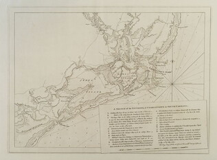
A Sketch of the operations before Charlestown [Charleston, S.C.]....
The key provides detailed military information. Nebenzahl, Battle Plans of the American Revolution, 136.
GLC03103.13
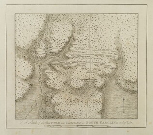
A Sketch of the battle near Camden in South Carolina, August 16, 1780
Nebenzahl, Battle Plans of the American Revolution, 89, who notes that the order of battle is correct while the terrain appears to be inaccurate.
GLC03103.14
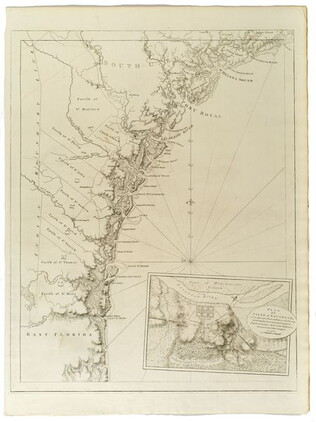
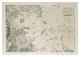
Untitled chart of the coast of Georgia and South Carolina [Savannah]
Includes small plan of the siege of Savannah in a cartouche.
GLC03103.15
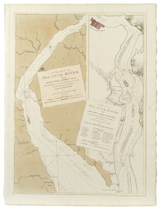
A Chart of the Delawar [Delaware] River, etc. with military key
Two views of the upper and lower river, showing the place of Philadelphia on it. Surveys from 1777. Nebenzahl, Battle Plans of the American Revolution, 136.
GLC03103.10
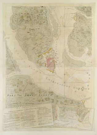
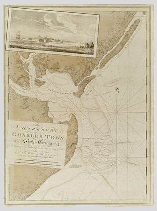
The Harbour of Charlestown [Charleston] in South Carolina
With a view of the city from the south side. Not in Nebenzahl, Battle Plans of the American Revolution.
GLC03103.11
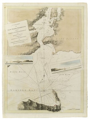
A Chart of New York Harbour
Not in Nebenzahl "Battle Plans of the American Revolution."
GLC03103.08
1781
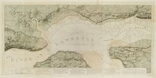
A Chart of the harbour of Rhode Island and Narraganset Bay
The key shows the French and English fleets. Surveyed 7/20/1776. Nebenzahl, Battle Plans of the American Revolution, 36.
GLC03103.02
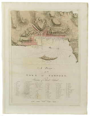
A Plan of the town of Newport
Companion print and detail of #3103.02, the chart of Rhode Island. Not in Nebenzahl, Battle Plans of the American Revolution.
GLC03103.03
A Chart of Boston Harbour, 1781
Possibly a later impression of Nebenzahl, Battle Plans of the American Revolution, 3, who notes that it comes principally from the survey of George Callendar, 1769.
GLC03103.04
circa 1775
[Two wall maps of the province of New York and surrounding areas] [Decimalized]
GLC03101
1780-1781
The Atlantic Neptune [selected maps and charts]
GLC03103
A Plan of Quebec and environs... in 1759
Not in Nebenzahl, Battle Plans of the American Revolution.
GLC03103.01
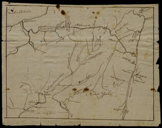
October 1781
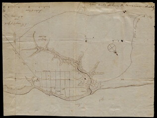
Unknown
[Map of Yorktown, Virginia]
Drawn map of Yorktown, Virginia. Shows roads, rivers, and other land markings, but not fortifications. With Cornwallis autograph note written across the front: "you will deliver the town immediately." Likely created by the British right before the...
GLC02437.10669
3 August 1781
Lincoln, Benjamin (1733-1810)
[Map of Charleston, South Carolina]
Manuscript map of Charleston, South Carolina showing the coastline, various rivers and geographic features, certain structures and county names. Date and creator inferred, based on the presumption that this map accompanies GLC02437.01112.
GLC02437.01113
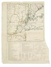
10 January 1774
Dunn, Samuel (fl. 1774)
North America as divided amongst the European powers
From The American Military Pocket Atlas (London, 1776), used by the British forces in the American Revolutionary War. "39" written on top right and bottom right corner of map. Reference numbers: Lowery 563. Phillips, Atlases 1206.
GLC02373
Faden, William (fl. 1750-1836)
A Plan of the city and environs of Philadelphia
Surveyed by N. Scull and G. Heap, engraved by William Faden. Includes military information relative to the American Revolution. Also has an inset image of Independence Hall, where the Declaration of Independence was adopted.
GLC02118
1 November 1776
Hawkes, W. (fl. 1776)
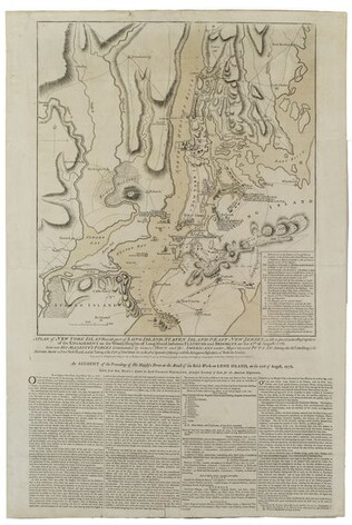
The Country twenty-five miles round New York
Irregular shaped paper. Engraving with letterpress chronological table of events from 1773-Oct. 1776, engraved by J. Barber and printed by W. Hawkes. Irregularly shaped. Nebenzahl, Battle Plans of the American Revolution, 110, who notes that a later...
GLC02005
Ratzer, Bernard
Plan of the City of New York in North America
Engraved by Jeffrey and Fagan. Oversize engraving showing lower Manhattan Island, part of Brooklyn and Hoboken, N.J. A cartouche extending across the bottom has a panoramic "South West View of the City of New York." Based upon the survey of 1766...
GLC02006
25 February 1777
A Plan of Operations... in New York... [Battle of White Plains]
First state with original handcolor. With C. Sauthier. "A plan of the operations of the King's army under the command of General Sir William Howe, K. B. in New York and East New Jersey, against the American Forces commanded by General Washington...
GLC06465
Brassier, William (fl. 1776)
A survey of Lake Champlain, including Lake George, Crown Point... 1762
Includes (inset) "A particular plan of Lake George." The engraved map shows engagements between American and British forces on Lake Champlain. Not in Nebenzahl, Battle Plans of the American Revolution.
GLC01874
circa February 1782
Bauman, Sebastian (1739-1803)
Plan of the investment of York and Gloucester
Drafted at Washington's request, shortly after the battle of Yorktown, Virginia. Nebenzahl, Battle Plans of the American Revolution, 189, with references.
GLC01869
circa 1780
A sketch of the operations before Charlestown, the capital of South Carolina
Large engraved map showing military operations, fortifications and outlying plantations, together with shallows and swamps. Shows positions of the various army units and notes that the Americans surrendered the city on 12 May 1780. Imprint from...
GLC01859
1779
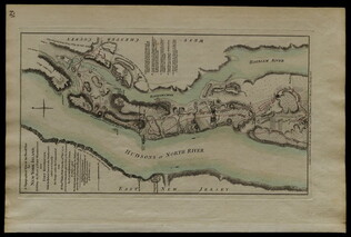
Plan of Fort Montgomery and Fort Clinton
From the Atlantic Neptune. Engraved and tinted map showing the Hudson River by Anthony's Nose with the Americans' chains across the river. Plate no. 19. (The map mistakenly calls the mountain "St. Anthony's Nose.") Nebenzahl, Battle Plans of the...
GLC01850
The American military pocket atlas; being an approved collection of correct maps
First issue in original boards, rebacked. Bookplate of Arthur Haynsworth Masten; ticket of T. Connolly, Bookseller, Dublin. Also with bookplate of Arthur Haynsworth Masten and inscription of "Jimmy [?] Browne / Augt. 1843" on titlepage. Full title...
GLC00257
1770
Rollos, George, (fl. 1770)
An Accurate Map of Africa Drawn from the Sieur Robert with Improvements
One map entitled An Accurate Map of Africa Drawn from the Sieur Robert with Improvements, dated 1770. Contains the entire continent of Africa, as well as a small portion of the Middle East. The island of Madagascar is also included. The map notes...
GLC09862.02
1 March 1777
A topographical map of the North part of New York Island establishing the plan of Fort. Washington, now Fort Knyphausen
Depicts northern Manhattan's Fort Washington which was captured by British forces on 11/16/1776. Copper engraving with older contemporary color. Describes and maps the four attacks by General Knyphausen on Fort Washington. "Hudsons or North River"...
GLC02394
10 August 1776
A Plan of the attack on Fort Sulivan, near Charles Town in South Carolina. by a Squadron of His Majesty's Ships, on the 28th of June 1776. with the Disposition of the King's Land Forces, and the Encampments and Entrenchments of the...
Title continues: "Rebels from the Drawings made on the Spot." Mentions Lieutenant Colonel Tho[mas] James of the Royal Regimental Artillery. Hudson River is hand colored. Kenneth Nebenzahl's "Battle Plans of the American Revolution", page 64.
GLC03283
01 March 1777
A topographical map of the North[er]n part of New York Island, Exhibiting the Plan of Fort Washington, now Fort Knyphausen, With the Rebels Lines to the Southward, which were Forced by the Troops under the Command of the Rt. Hon[ora]ble Earl Percy...
Title continues: "on the 16th Nov[embe]r 1776, and Survey'd immediately after by order of his Lordship by Claude Joseph Sauthier. To which is added the Attack made to the North by the Hessians. Survey'd by Order of Lieut[enan]t Gen[era]l Knyphansen."...
GLC03237
19 October 1776
A Plan of New York Island with part of Long Island... [first issue]
Nebenzahl, Battle Plans of the American Revolution, 107. Engraving with hand-coloring. This is the first issue, the only issue to show Manhattan in American hands.
GLC03533
November 1776
Sayer, Robert (fl. 1776)
The Theatre of war in North America [with:] A compendious account....
Not in Nebenzahl, Battle Plans of the American Revolution, but possibly related to 6 (?). With text "A Compendious Account of the British Colonies in North America" which contains a 1765 popluation chart of the British Colonies in North America...
GLC03285
10 June 1775
Montrésor, John (1736-1799)
A Map of the Province of New York with part of Pensylvania, and New England, from an actual survey by Captain Montrésor, Engineer, 1775
Includes insets of Connecticut River area and Lake Champlain area. Shows upper New York, Connecticut, Vermont. Framed to 92.7 x 113 cm. "P. Andreus, Sculpter" appears in lower right corner.
GLC03101.01
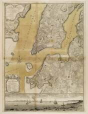
[Map of Lower New York State and surrounding areas]
Full title "To the Right Honourable Sir Jeffrey Amherst Knight of the Bath and Lieutenant General of his Majesty's forces etc., This map of the Province of New York is humbly Inscribed by His most obliged humble servant John Montresor, Engineer."...
GLC03101.02
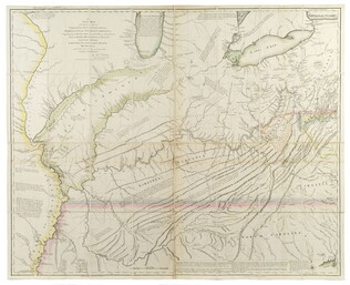
1778
Hutchins, Thomas (1730-1789)
A New map of Virginia, Pennsylvania....[with book:] A Topographical description
First edition, second issue. One of the most important early geographical descriptions of the West. Graff 2029, Howes H846. Accompanied by book. Not in Nebenzahl, Battle Plans of the American Revolution. Ex-Newberry Library. The map on light...
GLC03638
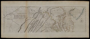
Fry, Joshua (fl. 1775)
A Map of the inhabited part of Virginia... [compiled with Peter Jefferson]
There are two prints in this document set, both are copper engravings with original outline color added. They combine to form a single map of a portion of the Colonies. The first is of Eastern Pennsylvania with the misspelling "Pensilvania", from...
GLC03557
[1768/11]
Indian Boundary Line as Settled by Sr. William & them in Nov[ember[ 1768
GLC03107.02166
Showing results 1 - 50