Self-Paced Courses: Explore American history with top historians at your own time and pace!
30 March 1774
Flucker, Thomas (1719-1783)
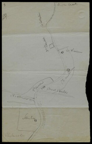
[Map of land]
A drawn map of land, likely located in Maine, deeded to Francis Waldo from Thomas and Hannah Flucker. Shows lakes, rivers, and boundary lines. Date taken from docket.
GLC02437.10645
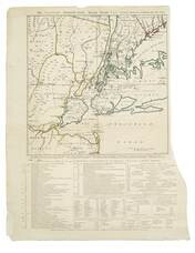
1 November 1776
Hawkes, W. (fl. 1776)
The Country twenty-five miles round New York
Irregular shaped paper. Engraving with letterpress chronological table of events from 1773-Oct. 1776, engraved by J. Barber and printed by W. Hawkes. Irregularly shaped. Nebenzahl, Battle Plans of the American Revolution, 110, who notes that a later...
GLC02005
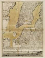
1776
Ratzer, Bernard
Plan of the City of New York in North America
Engraved by Jeffrey and Fagan. Oversize engraving showing lower Manhattan Island, part of Brooklyn and Hoboken, N.J. A cartouche extending across the bottom has a panoramic "South West View of the City of New York." Based upon the survey of 1766...
GLC02006
1861
Bachmann, John (fl. 1849-1885)
Bird's-eye view of Texas and part of Mexico
From the series: Panorama of the Seat of War.
GLC03484
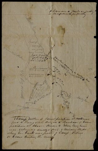
circa 1863-1865
Hoyt, Frank A. (fl. 1863-1865)
[Manuscript drawing of the camp of the 3rd Wisconsin Cavalry Regiment]
Shows the various buildings and structures in camp, including barracks, a sawmill, barns, and a steam furnace. The buildings are numbered and there is a corresponding legend on the verso. Drawn in pencil with a colored flag. The regiment operated...
GLC03050
circa 25 December 1864
Tower, Zealous Bates (1819-1900)
[Pencil illustration depicting the area near Nashville, Tennessee]
Autograph map depicts roads, rivers, fortifications and estimated troop numbers and locations near Nashville. Tower, chief engineer of Union defenses at Nashville, possibly transmitted this map with a letter (refer to GLC00849.01) to William P...
GLC00849.02
1865
General Benham's winter camp near Poplar Grove Church, Va., with photo of troops
Printed map, "Winter Camp, Detachment 50th N.Y.V. Engineers" Brevet Colonel I. Spalding Commanding, near Poplar Church, Virginia, Army of the Potomac, 1865. Has been partially hand colored. An original albumen photograph of soldiers with musical...
GLC00919.26
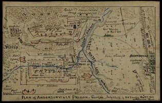
July 1864
Sneden, Robert Knox (1832-1918)
Plan of Andersonville Prison
Plan of the prison camp drawn by Sneden, a member of the 40th New York Volunteers imprisoned there in 1863-1864. Completed in ink and colored pencil. Sneden's map differs from other contemporary sketches.
GLC02244
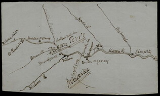
circa June 1872
Hemans, Daniel W. (fl. 1872-1881)
[Hand-drawn map of Dakota mission area]
Depicts the missions and Indian agencies along about fifty miles of the Missouri River west of Sioux City. Hemans discusses making the map for Frances Shiras to answer her question about the spatial relationship between the Santee, Yankton, and Ponca...
GLC02429.03
GLC02429.04
1860
Unknown
Map of Georgetown and the City of Washington
GLC09118.53
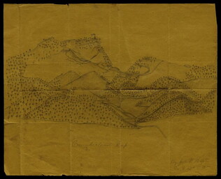
circa 1862-1865
Hopte, John W. (fl. ca. 1862-1865)
[Pencil illustration of the Cumberland Gap]
Depicts rolling mountainsides dotted with trees. Portrays forts, roads and other details specific to Civil War sites and events. Shows a rifle pit and an American flag waving atop a fortress. Signed by Hopte, who served in Company G, 42nd Regiment...
GLC03604
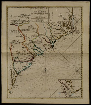
circa 1696
Sanson, Nicholas (1600-1667)
Carte generale de la Caroline dresse sur les memoirs le plus nouveaux
Map of North and South Carolina in an early period of settlement. Includes an inset of the area around Charleston, which locates plantations. This copy has a pencil note "1740" in margin, but no evidence for dating. In fact, this map remained...
GLC05236
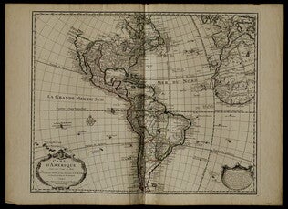
1722
De L'Isle, Guillaume (fl. 1718-1722)
Carte d'Amerique
Mercator projection including North and South America, with parts of Western Europe and Africa. Boundaries outlined in color. Shows North America from French perspective with English colonies restricted to the coast. Includes latitude and longitude...
GLC05238
Bird's-eye View of North and South Carolina and Part of Georgia
From the series: Panorama of the Seat of War. Locations of cities, towns, and military posts are identified as well as locations of naval ships. "Drawn from nature and lithographed by John Bachmann." Includes a key stating the distances between...
GLC03525
Bird's-eye View of Louisiana, Mississippi, Alabama and Part of Florida
From the series: Panorama of the Seat of War. Shows the Mississippi River delta where the river flows into the Gulf of Mexico. Locations of cities, towns, and military posts are identified as well as locations of naval ships. "Drawn from nature...
GLC03526
circa August 1861
Paris, George (fl. 1861)
[Depicts the First Battle of Bull Run, or Manassas Plains, fought 21 July 1861]
Sketched in pencil and ink, with a later note describing Paris as a Mississippi soldier. Includes locations, camps, and positioning of troops. Inscribed on verso to George's mother Mary C. Paris.
GLC08432
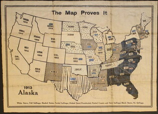
circa 1919
unknown, fl. 1919;
The Map Proves It [Women's suffrage map]
One map entitled "The Map Proves it" published circa 1919. This map illustrates the United States with different shading and colorizations of each state. The patterns and colors illustrate the status of the states in regards to women's suffrage...
GLC09773
18 December 1943
Polgar, Lillian (fl. 1943-)
homemade map to Lillian and Frank's house
Hand drawn and colored map to Lillian and Frank Polgar's house. On the left of the drawing there are notes that say housewarming, and fifth wedding anniversary.
GLC09414.1568
1815-1860
[Map of Sanders property given to Joshua Sanders]
GLC09302.007
1935
P.W.A. in Action
One map entitled, "P.W.A. in Action," dated 1935. Map consists of an illustration of the United States; including each of 50 states identified by a local Public Works program. Programs mentioned are related to housing, transportation, defense, museum...
GLC09879
Showing results 1 - 21