1671
Montanus, (fl. 1670-1671)
Map
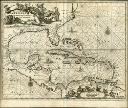
Title: Insulae Americanae in Oceeano Septentrionali cum Terris adiacenibus [Map of the Americas]
A map entitled, "Insulae Americanae in Oceano Septentrionali cum Terris adiacenibus" dated circa 1671. The map features Florida, the Gulf of Mexico, Cuba, the island of Espanolia which is modern day Haiti and Dominican Republic, Jamacia, Puerto Rico and many small islands. The map features the countries and cities on the coast of Central America and South America; Honduras, Nicaragua, Cartagena, S. Martha and Venezuela. Also along the coast and within the islands many cities are named. There are images in the top left and bottom right corners of indigenous people working and leaving to hunt…
GLC09789