Self-Paced Courses: Explore American history with top historians at your own time and pace!
1860
Unknown
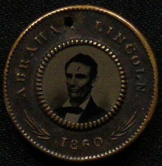
[Republican campaign token for 1860 election]
With photographs of Abraham Lincoln and Hannibal Hamlin, on opposing sides. Stamped with their names and the year. Gold border. Punched with hole at top.
GLC04102.04
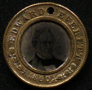
[Bell/Everett campaign token for 1860 election]
With photographs of Edward Everett and John Bell, on opposing sides. Stamped with their names and the year. Gold border. Punched with hole at top. Bell and Everett ran on the Constitutional Union ticket.
GLC04102.05
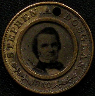
[Democratic campaign token for 1860 election]
With photographs of Stephen A. Douglas and Herschel V. Johnson, on opposing sides. Stamped with their names and the year. Gold border. Punched with hole at top. Douglas and Johnson ran on the Northern Democratic ticket.
GLC04102.06
1864
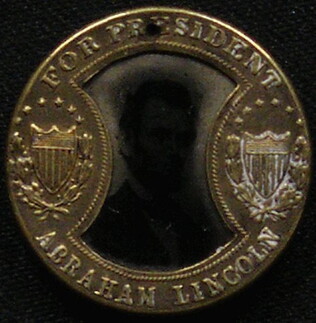
[Republican campaign token for 1864 election]
With photographs of Abraham Lincoln and Andrew Johnson, one of each side. Stamped with their names and "for President," "for Vice-President." Gold border. Punched with hole at top.
GLC04102.07
1852
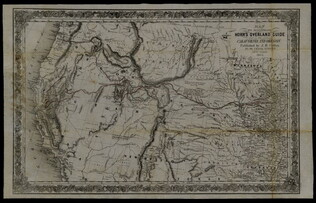
Horn, Hosea B. (fl. 1852)
Map to Illustrate Horn's Overland Guide to California and Oregon
Map originally attached to Horn's overland guide (housed with books, GLC 4152.01), from the U.S. Indian sub-agency, Council Bluffs, on the Missouri River, to the City of Sacramento, in California containing a table of distances, and showing all the...
GLC04152.02
1857
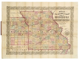
Wells, John G. (John Gaylord) (1821-1880)
Well's new map of Missouri and Eastern Kansas
This is a fold out map contained within a book measuring 14.5 x 9 cm. When unfolded, the full title displayed on the map is "Well's New Railroad and Township Map of Missouri and Eastern Kansas from the latest Government Surveys." Contains a large...
GLC04174
no date
[metallic token with lithograph of Lincoln]
Metallic token painted black with gold designs and gold back. Center of token has colored lithograph of Lincoln under glass
GLC05136.53
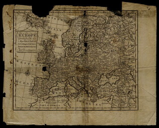
1758
Bennett, R. (fl. 1758)
Map of Europe describing its empires, kingdoms, and republics
GLC03107.05299
"For Vice-President, Henry Wilson of Massachusetts."
Card. [Ran for Vice-President in 1872. Died while in office, November 1875.]
GLC04360.051
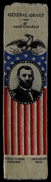
Campaign ribbon for General Grant
Red, white and blue campaign ribbon for General Grant. "General Grant, our, Next President." Flag bunting with portrait of Grant. "Jordan Tschopp., Fabricant. Switzerland, Basel."
GLC04360.052
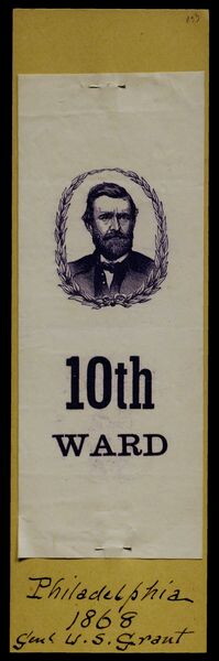
Purple printed paper campaign ribbon with portrait of Grant
10th Ward. Purple printed paper campaign ribbon with portrait of Grant; ink inscription on mount reads: "Philadelphia, 1868, Genl. U.S. Grant."
GLC04360.053
1896/06/16
Republican National Convention Cloth Ribbon
"Republican National Convention St. Louis, Mo. June 16th 1896." With seal of "Young Men's Republican Club, Baltimore, Maryland." Printed Cloth Ribbon. [from Grant family archives]
GLC04360.055
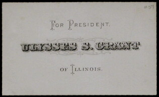
Card. "For President Ulysses S. Grant of Illinois."
GLC04360.057
1856
Fremont, John Charles (1813-1890)
Free Soil, Free Speech, Free Press. Fremont. [Fremont & Dayton election ribbon]
White printed ribbon depciting Fremont as the explorer, mounted on a horse and pointing? to the left.
GLC05510
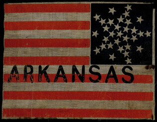
[State flag printed "Arkansas"]
Cotton Arkansas state flag with red and white stripes and a blue field with stars; "ARKANSAS." painted in black at center. Accompanied by a much later note reading: "[From the] Wigwam Convention 1860 - Chicago. State flag for Abraham Lincoln."
GLC05523
Lincoln, Abraham (1809-1865)
[Lincoln and Hamlin presidential election campaign banner, with eagle].
Printed cotton campaign banner showing an eagle with a long ribbon in his beak reading "Lincoln and Hamlin." The eagle holds a colored Columbia shield in its talons and only 6 arrows. Black ink (printed) with red and blue added in the shield.
GLC05553
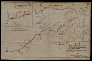
ca. 1818-1821
Gavit & Duthie (fl. 1840-1850)
Map of the Frontiers of the Northern Colonies with the Boundary Line established Between them and the Indians at the Treaty held by S. Will Johnson at Ft. Stanwix in Novr. 1768.
This document is a map that shows the Colonies of New York, New Jersey, Maryland, Virginia, and the Ohio Valley Territory to the west of them. The map contains corrections and improvements from the Evans Map made by Guy Johnson, who was a British...
GLC05634.08
[n.d.]
Hat
War Department general staff hat insignia with eagle and shield.
GLC06196.114
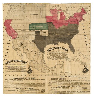
1856 ca.
To the free men of the North [election] [large cloth-backed lithographed map]
Free Labor Party abolitionist map used during the 1856 presidential campaign, printed, with hand-coloring in red, black and green.
GLC06662
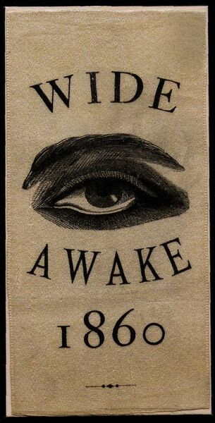
[Wide-awake election of 1860 campaign ribbon]
Republican campaign ribbon supporting Abraham Lincoln for President printed with "Wide Awake," and a large eye. Printed on white silk. Thousands of young men turned out in "Wide Awake" torchlight parades in support of Lincoln. The Wide Awakes are...
GLC05865
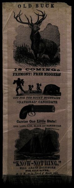
[Campaign ribbon on silk: "Old buck is coming"]
Faded pink silk ribbon with black ink images and text. Begins with an image of a buck (male dear), and the statement "Old Buck is Coming," referring to 1856 presidential candidate James Buchanan. Below the buck, the ribbon depicts blacks with...
GLC05877
The Boys in Blue Want Abe to Stay
GLC07744
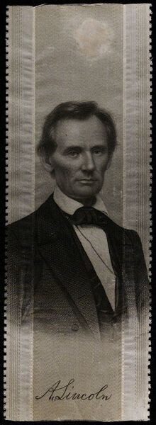
1860 ca.
1860 Pro-Lincoln campaign ribbon, based on Brady portrait
GLC07769.01
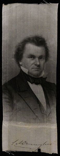
Douglas, Stephen Arnold (1813-1861)
1860 Pro-Douglas campaign ribbon, based on Brady portrait
GLC07769.02
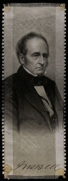
Bell, John
1860 Pro-Bell campaign ribbon, based on Brady portrait
GLC07769.03
Showing results 26 - 50