MA in American History: Apply now and enroll in graduate courses with top historians this summer!
1864
Richardson, W.
[Battle map]
Hand-drawn battle map of the movements of the 23rd Army Corps during the siege of Atlanta, with positions of the Union and Confederate forces in Resaca, Marietta, and Atlanta.
GLC09321
July 1863
Manuscript map of Gettysburg battlefield
With annotations describing the battle and its aftermath. "Perfect desolation everything shot away dead reables [sic] & horse trees bushes & fence & posts all gone a perfect valley of death."
GLC09181
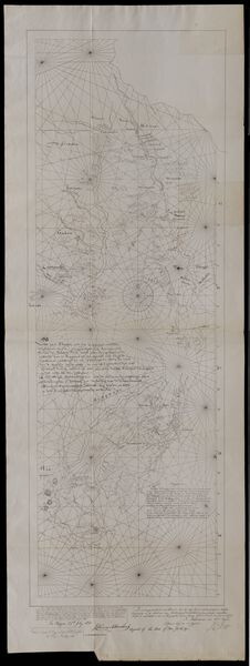
27 July 1841
Sarony & Co. (1854-1857)
[Facsimile of map of New Netherlands using the names of Native American tribes to indicate location]
Printed on the bottom left corner is the signature of John Romeyn Brodhead, an agent of the State of New York hired to procure and transcribe documents in Europe. Signed by P.H. Loffelt, who copied this document for Brodhead in the Hague, and by J.C...
GLC05859.02
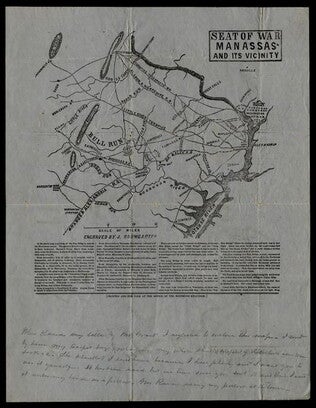
1861
Baumgarten, J. (fl. 1861)
Seat of War Manassas and its Vicinity
Printed map detailing the battleground of 18 and 21 July 1861 at the Battle of First Manassas (Bull Run). Includes major roads and railroads, showing Washington D.C. on the right side. Contains descriptive text beneath the map. At the bottom is a...
GLC05987.26
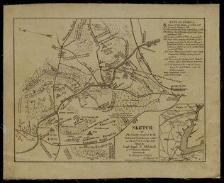
Mitchell, Samuel P. (fl. 1861)
Sketch of the Country Occupied by the Federal & Confederate Armies on the 18th & 21st July 1861
Detailed map of the Battle of Manassas (Bull Run) showing roads, topographical features, troop positions, batteries, bridges, and railroads. Also has a legend of "Explanations." Pictures the battle field to the north of Manassas, with the Bull Run...
GLC05987.25
Showing results 16 - 20