MA in American History: Apply now and enroll in graduate courses with top historians this summer!
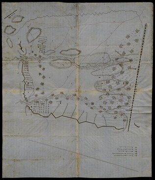
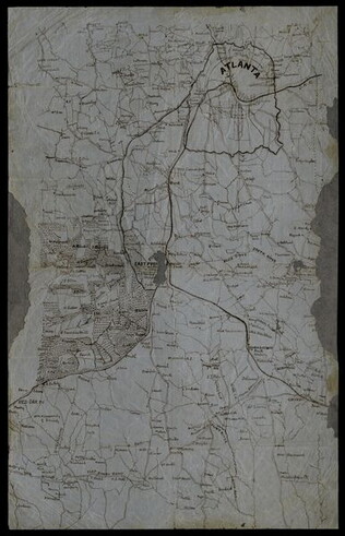
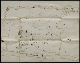
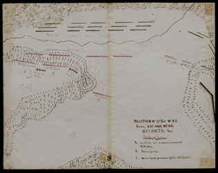
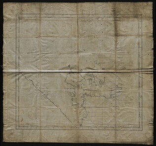
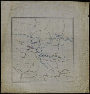
1864
Richardson, W.
[Battle map]
Hand-drawn battle map of the movements of the 23rd Army Corps during the siege of Atlanta, with positions of the Union and Confederate forces in Resaca, Marietta, and Atlanta.
GLC09321
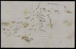
circa 23 May 1863
Winn, Charles A. (fl. 1863)
[Battle of Gum Swamp]
Shows the Confederate and Union lines, the locations of a Massachusetts brigade attack and other skirmishes, and the arrangement of fields, woods, roads, and fences. Captain Winn, of Company G in the 58th Pennsylvania Infantry, commanded the skirmish...
GLC04158
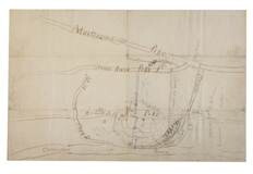
circa May 1863
Stanley, Lucius T. (1844-1934)
[Chancellorsville map showing Hooker, Jackson's attack, and site of the latter's death]
Shows Stonewall Jackson's route, his attack on the 11th Corps on 2 May 1863, and the "Place where Jackson was killed." Many annotations on reconnaissance, military activities, and places occupied by certain commanders, including Joseph Hooker. Shows...
GLC02710.37
1863
Jenney, William Le Baron (1832-1907)
[Civil War map of Mississippi and Alabama]
Covers northern segments of the two states, showing towns, watercourses, railroads, and roads. Also shows Corinth and vicinity. The Tennessee River appears prominently, colored with a light blue paint wash. The map is painted and drawn on a coated...
GLC07086.03
1862
[Civil War maps] [decimalized]
Eight maps of various media, mostly of General McClellan's Peninsula Campaign.
GLC04355
May 1862
Unknown
[Confederate Civil War map of the Army of Mississippi camp at Corinth, Mississippi]
Manuscript map shows the lines of entrenchments and reinforcements, the Danville Road, cultivated land, camp roads, a cotton press, the O & M Railroad and C & M Railroad, and General William J. Hardee's headquarters. Map was blind stamped while...
GLC05668
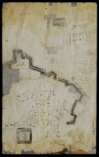
circa 5 January 1862
Gorsuch, Joseph B. (1834-1908)
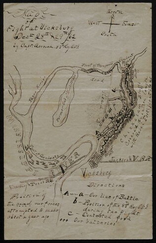
[Depiction of the battle of Chickasaw Bayou]
Drawn by Gorsuch, Captain of the 83rd Regiment Ohio Volunteer Infantry. Depicts the Yazoo River, fleet location, Confederate fortifications, Chickasaw Bayou, the Mississippi River, and the Vicksburg Texas Railroad, among other details. Indicates...
GLC00653.09.02
circa August 1861
Paris, George (fl. 1861)
[Depicts the First Battle of Bull Run, or Manassas Plains, fought 21 July 1861]
Sketched in pencil and ink, with a later note describing Paris as a Mississippi soldier. Includes locations, camps, and positioning of troops. Inscribed on verso to George's mother Mary C. Paris.
GLC08432
circa April 1862
[Field map made prior to the Civil War battles of Shiloh and Corinth]
This document is a manuscript map that shows major roads from Corinth to the Tennessee River, houses and their inhabitants, and occasionally their sympathies along the route. It also includes other topographical features. Drawn in pencil and brown...
GLC05759
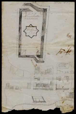
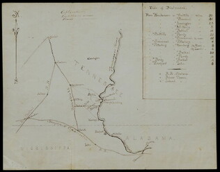
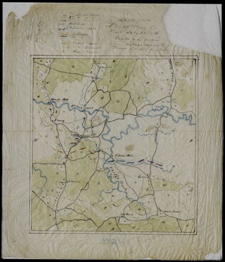
February 1864
Jones, Joseph
[Fort of Sweetwater, Tennessee]
GLC02739.101
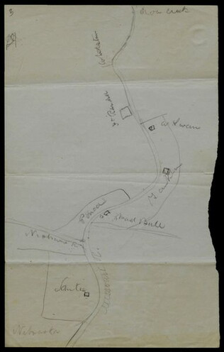
circa June 1872
Hemans, Daniel W. (fl. 1872-1881)
[Hand-drawn map of Dakota mission area]
Depicts the missions and Indian agencies along about fifty miles of the Missouri River west of Sioux City. Hemans discusses making the map for Frances Shiras to answer her question about the spatial relationship between the Santee, Yankton, and Ponca...
GLC02429.03
GLC02429.04
circa 1864
[Manuscript Civil War map of Atlanta and vicinity]
Detailed map on blue lined paper of Atlanta and environs from General Sherman's Atlanta campaign. Shows roads, railroads, forests, and rivers. Directions and latitude not given.
GLC01924
circa January 1863
[Manuscript Civil War map of Dover, Tennessee, showing battlefield and artillery]
Shows Confederate line of batteries, roads, rivers, and ravines. Also shows the town layout with gun placements and building locations. Approximately forty buildings appear, including the headquarters of the 83rd Illinois Regiments, Colonel A.C...
GLC04042.01
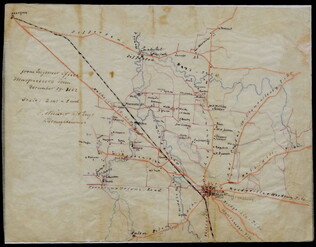
Stephens, Asbury L. (b. 1843)
[Manuscript Civil War map of General Sherman's Atlanta campaign]
Shows the route of Sherman's march from Chattanooga, Tennessee starting on 4 May 1864 and culminating with the siege of Atlanta on 8 September 1864. Drawn in black, red, yellow, and green ink on linen.
GLC04498.01
29 December 1862
Meister, C. (fl. 1862)
[Manuscript Civil War map of Murfreesboro, Tennessee]
Shows Murfreesboro and the areas north and west of it, along with names of property owners. Drawn shortly before the Battle of Stones River (Murfreesboro), providing evidence that General Braxton Bragg originally planned to attack the Union forces...
GLC02588
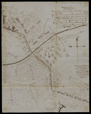
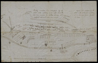
27 July 1864
Snell, J.P. (fl. 1864)
[Manuscript Civil War map of the Battle of Atlanta]
Presented by Snell to Asbury Stephens, "one of the participants this 23d. day of Sept. 1864, at Eastpoint, Ga." Shows where the 2nd Brigade crossed the railroad, moved into battle, position at the works, and its efforts to repulse the Confederates...
GLC04498.03
Baum, A. Clark (b. 1832)
[Manuscript Civil War map of the Battle of Chancellorsville]
Shows the U.S. Mine Ford. Also shows three pontoon bridges over the Rappahannock River, various Confederate batteries and rifle pits, hospital locations, and the location of Fitzhugh House. References to a skirmish on a Sunday night and a shelling...
GLC06013.01
circa December 1862
[Manuscript Civil War map of the Battle of Fredericksburg]
Shows bridges, batteries, hospitals, positions of Confederate sharpshooters, the railroad and Falmouth Station, and various buildings, including Lacy House. Also shows the movement across a bridge of Captain Wesley Brainerd. There are photographs...
GLC06013.02
circa 7 December 1862
Brooks, Alfred F. (fl. 1862-1863)
[Manuscript Civil War map of the Battle of Murfreesboro]
Hand-colored map depicting Confederate and Union troop and artillery positions, and the location of a hospital. Brooks was the Acting Topographical Engineer, 2nd Brigade, 5th Division, 14 Army Corps.
GLC06162
circa November 1863
[Manuscript Civil War map of the Battle of Rappahannock Station]
Shows pontoon bridges, batteries, the Orange & Alexandria Railroad, various fortifications, the locations and movements of the 5th and 6th Army Corps, and the routes of Confederate reinforcements. Also shows General John Sedgwick's headquarters....
GLC06013.03
circa 5 May 1862
Smith, Henry W. (1836-1869)
[Manuscript Civil War map of the Battle of Williamsburg]
Shows the troop positions of forces under Union generals Philip Kearney and Joseph Hooker, as well as the Confederate line. Also shows the open field where the combatants met, Fort Magruder, and other structures. Smith is identified on the docket...
GLC06161
12 June 1862
Blanchard, C. D. (fl. 1862)
[Manuscript Civil War map of the battleground of the Battle of Seven Pines]
Shows roads, streams, and some troop positions. Drawn on a scale of 200 paces or 133-1/3 yards to an inch. The Battle of Seven Pines took place on 31 May 1862-1 June 1862. Blanchard served as Chief Quartermaster, 4th Corps. Mostly black & white...
GLC06061.01
circa February 1865
Aveleen, E. J. (fl. 1865)
[Manuscript Civil War map of the Confederate defenses around Sea Island, South Carolina]
Shows defenses between Secessionville and Fort Pringle, and down towards Forts Mahan and Delafield on Folly Island. James Island also appears. Shows the obstacles facing the Union's approach to Charleston, South Carolina in early 1865, including...
GLC06380
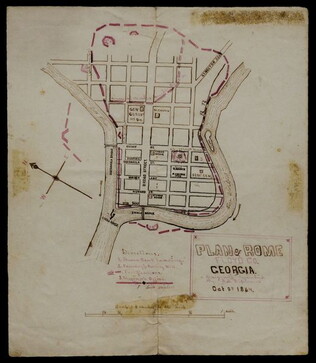
8 October 1864
[Manuscript Civil War map of the Plan of Rome, Floyd County, Georgia]
Shows the locations of fortifications, a steam boat landing, and troop positions. Made two days before General Hood's army skirmished with General Sherman's supply line near Rome, causing Sherman's forces to fortify themselves in the town. Colored...
GLC04498.04
[Manuscript Civil War map of the position of an army division at the Ogeecheee River in Georgia]
Shows the position of the 4th Division of the 15th Army Corps, the road to Savannah, the Confederate lines across the swamp. Also shows positions of various troops and General William T. Sherman's headquarters. Drawn in brown and pink ink a month...
GLC04498.05
22 July 1864
[Manuscript Civil War map of the position of the 2nd Division, 16th Army Corps in the Battle of Atlanta]
Shows the Confederate line, the positions of Union brigades, and a skirmish in the Battle of Atlanta. The legend indicates the positions at the beginning of the battle, the charging that occurred ("Rebel line charging") and the new line that was...
GLC04498.02
February 1865
[Manuscript Civil War map of the siege of Columbia, South Carolina]
Circular map showing the position of the 4th Division of the 13th Army Corps, rivers, railroads, and roads around Columbia. General Sherman's siege was on 16-17 February 1865. Drawn in brown and pink ink.
GLC04498.06
24 February 1862
Jordan, F. H. (fl. 1862)
[Manuscript Civil War map of the site of the Battle of Shiloh]
Entitled on docket: "Sketch of County embraced in a Reconnoissance made by Capt. F.H. Jordan." Also has a "Table of Distances." Pencilled "No. 2" on the front. An additional docket reads : "Jackson. Tenn March 20 [or 2d] 1862." Shows the Tennessee...
GLC02333
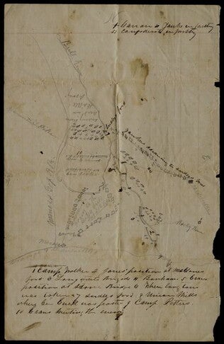
circa 1863-1865
Hoyt, Frank A. (fl. 1863-1865)
[Manuscript drawing of the camp of the 3rd Wisconsin Cavalry Regiment]
Shows the various buildings and structures in camp, including barracks, a sawmill, barns, and a steam furnace. The buildings are numbered and there is a corresponding legend on the verso. Drawn in pencil with a colored flag. The regiment operated...
GLC03050
20 March 1862
Worret, Charles (b. 1819)
[Manuscript map, Military Reconnaissance Dept. Va]
Title continues: "Major Genl. Wool Comdg. Drawn by Sergt. Worret & Compiled Under the Direction of Colonel T.J. Cram Chief Topl. Engr. Dept. Va." "Copy." Shows the Yorktown Peninsula and contains a description of the area in terms of its potential...
GLC04355.01
[Map of fortifications]
GLC02739.159
Bush, George (fl. 1862)
[Map of Fredericksburg]
A fairly complete and accurate map of the Union position at Fredericksburg. Shows federal positions, pontoon bridges, geographic features, roads and houses used as hospitals. The position held by Gibbon's Division is slightly exaggerated.
GLC03607.08
no date
[Map of islands on the Sea of Okhotsk]
A hand-drawn map on linen of islands in the Sea of Okhotsk located on the coast of Russia between the Kamchatka Peninsula and Sakhalin Island. The map contains numbers throughout and depicts such places Big Shantar, Little Shantar, Bear Island, and...
GLC02016.181
West, Lewis H. (b. 1829)
[Map of southern tip of Florida and the Bahama Islands]
Hand drawn map of the southern tip of Florida and various islands in the Bahamas chain. Marks currents and their speed. Also notes where important lighthouses are located. The Great Bahama Bank and the Salt Bay Bank are demarcated. In both pencil...
GLC03836.89
4 July 1863
Howard, Richard L. (fl. 1863)
[Map of the front view of Vicksburg]
Howard, Chaplain of the 124th Illinois Infantry, depicts Vicksburg, Mississippi and the surrounding area in black and red ink. Illustrates the Mississippi and Yazoo Rivers, a cottonwood forest, the Vicksburg and Texas Railroad line (destroyed)...
GLC06382.03
circa 25 December 1864
Tower, Zealous Bates (1819-1900)
[Pencil illustration depicting the area near Nashville, Tennessee]
Autograph map depicts roads, rivers, fortifications and estimated troop numbers and locations near Nashville. Tower, chief engineer of Union defenses at Nashville, possibly transmitted this map with a letter (refer to GLC00849.01) to William P...
GLC00849.02
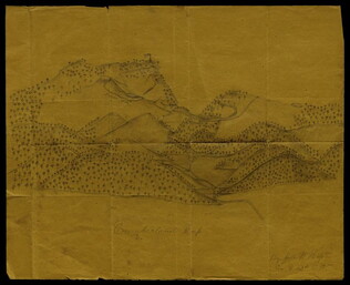
circa 1862-1865
Hopte, John W. (fl. ca. 1862-1865)
[Pencil illustration of the Cumberland Gap]
Depicts rolling mountainsides dotted with trees. Portrays forts, roads and other details specific to Civil War sites and events. Shows a rifle pit and an American flag waving atop a fortress. Signed by Hopte, who served in Company G, 42nd Regiment...
GLC03604
1862-1863
[Three manuscript Civil War maps of Fredericksburg, Chancellorsville, and Rappahannock Station] [Decimalized .01-.03]
Maps of battles at Fredericksburg, Chancellorsville and Rappahannock Station by A. Clark Baum of the 50th New York Volunteer Engineers.
GLC06013
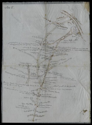
circa July 1864
[Union Civil War battlefield map of the Battle of Peachtree Creek]
Untitled draft of "Battlefield Peach Tree Cr. Fought July 20 1864 Scale 4 in. pr. mi. from actual Survey by Topogs. of 1st Div 20 Corps," found in GLC02710.35. Notes houses, Howel's Mill and Collier's Mill, a burned bridge, roads, and waterways...
GLC02710.36
1861-1865 ca.
Stanley, Lucius T. (1844-1934).
Archive of Civil War maps, mainly Atlanta campaign [word processed inventory available]
Collection of wartime manuscript maps with copies of other war items related to Stanley. 37 maps document Sherman's army from Chattanooga to Atlanta, the march to the sea and then up to the Carolinas. The last map (38) is the Battle of...
GLC02710
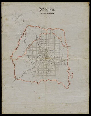
Atlanta, and its rebel defences
Printed Civil War map from the Atlanta Campaign. Names major streets. The Fair Ground, Cemetery, the Locomotive House of the W & A Railroad, the Atlanta Steam Tannery, White Hall, and the headwaters of South River are indicated. The tracks for the...
GLC02710.38
Bacon & Co. (fl. 1864)
Bacon's Large Print War Map Showing 50 Miles round Washington and Richmond
Shows major towns, waterways, and railroads. Concentric circles with intervals of ten miles each surround both Washington and Richmond. A red line shows General Ulysses S. Grant's route from Fredericksburg to Petersburg, Virginia, and a blue line...
GLC04175
Battlefield Peach Tree Cr. Fought July 20 1864 Scale 4 in. pr. mi. from actual Survey by Topogs. of 1st Div 20 Corps
Notes houses, roads, military trails, locations of Union, including 1-3 Divisions of the 26th Corps and Confederate troops, lines of artillery, and barracks. Items are identifiable though the legend on the top of the map. Signed "Stanley fecit." Map...
GLC02710.35
circa. 25 December 1864
Tower, Zealous B.
Battles before Nashville 15 & 16 December 1864 between U. S. Army commanded by Major Gen'l G. H. Thomas and Rebel Forces under Gen'l Hood
Autograph (lithograph) map entitled "Battles before Nashville 15 & 16 December 1864 between U. S. Army commanded by Major Gen'l G. H. Thomas and Rebel Forces under Gen'l Hood." Tower, chief engineer of Union defenses at Nashville, possibly...
GLC00849.03
1861
Bachmann, John (fl. 1849-1885)
Bird's-eye View of Louisiana, Mississippi, Alabama and Part of Florida
From the series: Panorama of the Seat of War. Shows the Mississippi River delta where the river flows into the Gulf of Mexico. Locations of cities, towns, and military posts are identified as well as locations of naval ships. "Drawn from nature...
GLC03526
Bird's-eye View of North and South Carolina and Part of Georgia
From the series: Panorama of the Seat of War. Locations of cities, towns, and military posts are identified as well as locations of naval ships. "Drawn from nature and lithographed by John Bachmann." Includes a key stating the distances between...
GLC03525
Bird's-eye view of Texas and part of Mexico
From the series: Panorama of the Seat of War.
GLC03484
Abbot, Henry L. (1831-1927)
Campaign Map Army of the Potomac, Map No. 3. White House to Harrisons Landing
Title continues: "Prepared by Command of Maj. Gen. George B. Mc.Clellan U.S.A. Commd'g Army of the Potomac A.A. Humphreys Brig. Gen. and Chief of Top. Engr's." Map compiled by Abbot. Photographed at the Coast Survey Office. A very faint brown-line...
GLC04355.05
"Prepared by Command of Maj. Gen. George B. Mc.Clellan U.S.A. Commanding Army of the Potomac Brig. Gen. A.A. Humphreys Chief of Top. Engrs Army of the Potomac." Print engraved by W.H. Dougal. Map compiled by Abbot.
GLC04355.06
Showing results 1 - 50