MA in American History: Apply now and enroll in graduate courses with top historians this summer!
1941
War Office
[Map of French coast from Cherbourg to Rouen]
A first edition European road map published by the War Office in 1941, showing the French coast from Cherbourg to Rouen.
GLC09557.01
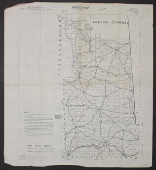
March 1944
War Department Corps of Engineers, U.S. Army
[Photo-map index]
A two-sided photo-map index of the English Channel. One side of the map shows Cherbourg, France, the English Channel, and Grande Rade. There is a grid over the map labled 1 to 29 on the y-axis and A to O on the x-axis. The reverse side of the map...
GLC09557.02
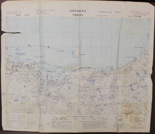
May 1944
Unknown
Defences Cherbourg
A two-sided map of the defences of Cherbourg, France. The shows the map itself, while the back has a large ledgend. There is a tear in the upper left quadrant of the map.
GLC09557.03
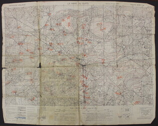
September 1943
U.S. Army
La Haye du Puits [French]
A map of La Haye-du-Puits, France. There are numbers handwritten in orange on the map, but it is unclear what they represent. The back of the map has "La Haye Du Puits 31/18 S.W.," written in red.
GLC09557.07
18 December 1943
Polgar, Lillian (fl. 1943-)
homemade map to Lillian and Frank's house
Hand drawn and colored map to Lillian and Frank Polgar's house. On the left of the drawing there are notes that say housewarming, and fifth wedding anniversary.
GLC09414.1568
circa 1940-1946
Cleartype Maps
[Cleartype General Map of the Pacific Ocean, Southeastern Asia, and Austrailia]
A map of the Pacific Ocean, Southeastern Asia and Austrailia. Copyright the American Map Company Inc. Originally published by Cleartype Maps. Contains Robert L. Stone's notes on where he traveled when he was deployed.
GLC09620.251
1935
P.W.A. in Action
One map entitled, "P.W.A. in Action," dated 1935. Map consists of an illustration of the United States; including each of 50 states identified by a local Public Works program. Programs mentioned are related to housing, transportation, defense, museum...
GLC09879
30 April 1941
Japan Cabinet Printing Bureau
General Map of Greater East Asian Co-prosperity Sphere and Pacific Ocean
Map of territories included in the Japanese propaganda concept, the "Greater East Asian Co-prosperity Sphere." The concept promoted the cultural and economic unity of the region by a self-sufficient bloc of Asian nations led by the Japanese and free...
GLC09552.11
Defences Lessay
A two-sided map of the defences of Lessay, France. The front shows the map itself, while the back has a large ledgend.
GLC09557.04
c.1943
Port en Bessin to Cherbourg [and] Entretat to Port Bessin
A two-sided map of the coastline of France. One side of the map shows the Port en Bessin to Cherbourg and the reverse side shows Entretat to Port Bessin. This map has three hole punches and is labled page 185 and 186, but the rest of the book or...
GLC09557.05
unknown
[Allied invasion of Normandy sectors]
A map of the five areas where Allied troops invaded Normandy on June 6, 1944.
GLC09557.06
Showing results 1 - 11