Self-Paced Courses: Explore American history with top historians at your own time and pace!
circa 1775-1776
Unknown
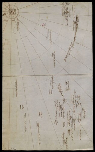
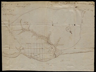
[Battle plan for the siege of Boston Harbor]
Mapped battle plan for an American siege of Boston Harbor. Shows boats and some major geographic markers. For written plans see GLC02437.00231.
GLC02437.00232
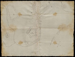
3 August 1781
Lincoln, Benjamin (1733-1810)
[Map of Charleston, South Carolina]
Manuscript map of Charleston, South Carolina showing the coastline, various rivers and geographic features, certain structures and county names. Date and creator inferred, based on the presumption that this map accompanies GLC02437.01112.
GLC02437.01113
circa 1782-1783
Bauman, Sebastian (1739-1803)
[Map of Forts Ontario and Oswego and surroundings]
Docketed as "A rough sketch of Oswego by Major Bauman." Shows Fort Ontario (captioned), Fort Oswego (uncaptioned) and surrounding features (possibly earthworks).
GLC02437.10667
30 March 1774
Flucker, Thomas (1719-1783)
[Map of land]
A drawn map of land, likely located in Maine, deeded to Francis Waldo from Thomas and Hannah Flucker. Shows lakes, rivers, and boundary lines. Date taken from docket.
GLC02437.10645
circa 1775
Montrésor, John (1736-1799)
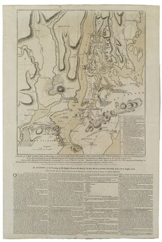
[Map of Lower New York State and surrounding areas]
Full title "To the Right Honourable Sir Jeffrey Amherst Knight of the Bath and Lieutenant General of his Majesty's forces etc., This map of the Province of New York is humbly Inscribed by His most obliged humble servant John Montresor, Engineer."...
GLC03101.02
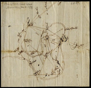
8 January 1777
[Map of roads in the vicinity of Morristown, New Jersey]
Indicates roads, some natural features, landmarks ("court house," "Whites Tavern Genl Lees," bridge, landing, etc.), outlying towns, and distance between points on the map. Indicates the location of towns surrounding Morristown. Notes the position...
GLC02437.09543
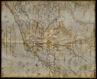
circa 1782
Erskine, Robert (1735-1780)
[Map of South Carolina]
A manuscript copy of a printed map of a portion of South Carolina. Shows lakes, rivers, streams, forest, towns, counties, and possibly roads. Noted, "Part of SOUTH CAROLINA copied by R. Erskine F. R. S. from A Map published in London 1771." Docket...
GLC02437.10611
October 1781
[Map of Yorktown, Virginia]
Drawn map of Yorktown, Virginia. Shows roads, rivers, and other land markings, but not fortifications. With Cornwallis autograph note written across the front: "you will deliver the town immediately." Likely created by the British right before the...
GLC02437.10669
4 July 1781
Storers, Christain (fl. 1781)
[Sketch of land]
Charles Miller signed the docket on 2 November 1801. A sketch of Christian Storers' surveyed land lying in "Waldowborough" [Waldoborough, Maine]. Includes written information regarding boundary lines and a drawn compass showing cardinal directions...
GLC02437.10646
Montrésor, John (1736-1799)
[Two wall maps of the province of New York and surrounding areas] [Decimalized]
GLC03101
1781
Barres, Joseph Frederick Wallet des (1722-1824)
A Chart of Boston Harbour, 1781
Possibly a later impression of Nebenzahl, Battle Plans of the American Revolution, 3, who notes that it comes principally from the survey of George Callendar, 1769.
GLC03103.04
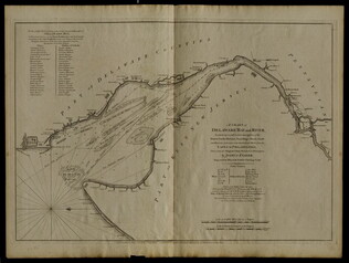
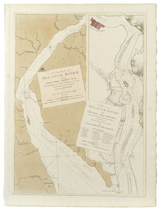
12 March 1776
Faden, William (ca. 1750-1836)
A Chart of Delaware Bay and River
Chart by Joshua Fisher. Depicts areas of Western New Jersey, Delaware, and Pennsylvania. There is extra shading on the shorelines of these states. Engraved by William Faden. Includes list of river pliots who subscribed to have it published. Slight...
GLC05237
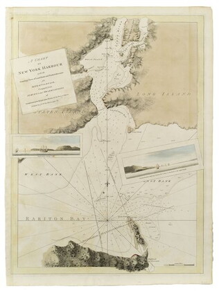
1780
A Chart of New York Harbour
Not in Nebenzahl "Battle Plans of the American Revolution."
GLC03103.08
A Chart of the Delawar [Delaware] River, etc. with military key
Two views of the upper and lower river, showing the place of Philadelphia on it. Surveys from 1777. Nebenzahl, Battle Plans of the American Revolution, 136.
GLC03103.10
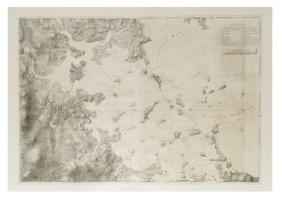
A Chart of the harbour of Rhode Island and Narraganset Bay
The key shows the French and English fleets. Surveyed 7/20/1776. Nebenzahl, Battle Plans of the American Revolution, 36.
GLC03103.02
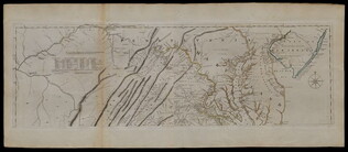
1775
Fry, Joshua (fl. 1775)
A Map of the inhabited part of Virginia... [compiled with Peter Jefferson]
There are two prints in this document set, both are copper engravings with original outline color added. They combine to form a single map of a portion of the Colonies. The first is of Eastern Pennsylvania with the misspelling "Pensilvania", from...
GLC03557
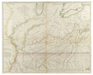
10 June 1775
A Map of the Province of New York with part of Pensylvania, and New England, from an actual survey by Captain Montrésor, Engineer, 1775
Includes insets of Connecticut River area and Lake Champlain area. Shows upper New York, Connecticut, Vermont. Framed to 92.7 x 113 cm. "P. Andreus, Sculpter" appears in lower right corner.
GLC03101.01
1778
Hutchins, Thomas (1730-1789)
A New map of Virginia, Pennsylvania....[with book:] A Topographical description
First edition, second issue. One of the most important early geographical descriptions of the West. Graff 2029, Howes H846. Accompanied by book. Not in Nebenzahl, Battle Plans of the American Revolution. Ex-Newberry Library. The map on light...
GLC03638
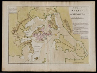
1776/03/12
Dury, Andrew (fl. 1776)
A Plan of Boston and its Environs... [siege of Boston]
Nebenzahl, Battle Plans of the American Revolution, 16.
GLC04410
19 October 1776
Faden, William (fl. 1750-1836)
A Plan of New York Island with part of Long Island... [first issue]
Nebenzahl, Battle Plans of the American Revolution, 107. Engraving with hand-coloring. This is the first issue, the only issue to show Manhattan in American hands.
GLC03533
1776/10/19
A Plan of New York island, with part of Long Island... [second issue]
Nebenzahl, Battle Plans of the American Revolution, 107. Second issue dated a month later than GLC 3533 (first issue). This map shows British control of Manhattan.
GLC04177
25 February 1777
A Plan of Operations... in New York... [Battle of White Plains]
First state with original handcolor. With C. Sauthier. "A plan of the operations of the King's army under the command of General Sir William Howe, K. B. in New York and East New Jersey, against the American Forces commanded by General Washington...
GLC06465
1777
A Plan of Quebec and environs... in 1759
Not in Nebenzahl, Battle Plans of the American Revolution.
GLC03103.01
1776/06/28
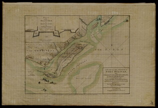
A Plan of the Attack on Fort Sulivan [Sullivan]... 28th of June 1776
Nebenzahl, Battle Plans of the American Revolution, 64.
GLC04317
10 August 1776
A Plan of the attack on Fort Sulivan, near Charles Town in South Carolina. by a Squadron of His Majesty's Ships, on the 28th of June 1776. with the Disposition of the King's Land Forces, and the Encampments and Entrenchments of the...
Title continues: "Rebels from the Drawings made on the Spot." Mentions Lieutenant Colonel Tho[mas] James of the Royal Regimental Artillery. Hudson River is hand colored. Kenneth Nebenzahl's "Battle Plans of the American Revolution", page 64.
GLC03283
Showing results 1 - 25