Self-Paced Courses: Explore American history with top historians at your own time and pace!
1770/07/09
Low, Isaac (1735-1791)
Advertisement. [a poll of New Yorkers regarding importation]
Not in Evans or Bristol. (Facsimile reprint was made by N.W. Allen, 1967, Schenedtady, N.Y.) Ex-Alexander McDougall Papers
GLC02554
1776/01/08 ca.
Committee of Public Safety. New York
Appeal to Members of NY Provincial Congress to attend February session
Issued by the New York Committee of Public Safety, appealing to New York's members of Congress. Also appeals on rejection of Lord North's reconciliation plan, which is intended to "disunite the colonies." From the Alexander McDougall papers.
GLC02555
1835/12/10
Texas. General Council.
To The People of Texas re: siege of Mexican garrison at San Antonio de Bexar
Streeter Texas 92. re siege of Mexican garrison at San Antonio de Bexar. Compared with Streeter copy at Yale University.
GLC02558
1846/01/14
Jones, Anson (1798-1858)
Proclamation re: admission of Texas to the Union, with John Tod ALS
Issued by Jones as President of the Republic of Texas, calling all Senators and Representatives to convene a state government. Accompanied by a 2 p. John Tod ALS, Galveston, concerning the proclamation, written while commanding in the Texas navy.
GLC02560
6 March 1848
Butler, William Orlando (1791-1880)
[Military convention for the provisional suspension of hostilities]
Order No. 18, ratified by William Orlando Butler as Major General Commanding on March 5,1848. Signed by Adjutant Irvin McDowell. Orders a suspension of hostilities following seventeen articles by the Military Convention. The Convention provisions...
GLC02561
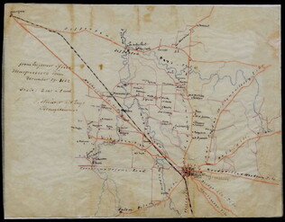
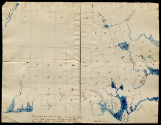
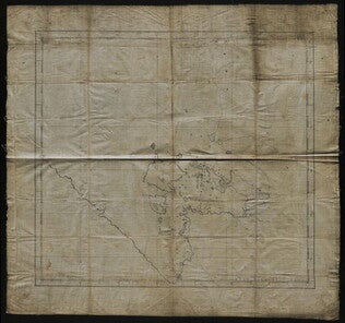
29 December 1862
Meister, C. (fl. 1862)
[Manuscript Civil War map of Murfreesboro, Tennessee]
Shows Murfreesboro and the areas north and west of it, along with names of property owners. Drawn shortly before the Battle of Stones River (Murfreesboro), providing evidence that General Braxton Bragg originally planned to attack the Union forces...
GLC02588
19 December 1862
Briscoe, James C. (d. 1869)
Position held by the 1st Divn. 3rd Corps After Having Repulsed the Enemy Decb. 13th 1862
Map sent with a letter written by Union General David B. Birney (see GLC02630.01). Shows the Union position on the battlefield at the Battle of Fredericksburg. Various picket lines, topographical features, and the locations of troops under generals...
GLC02630.02
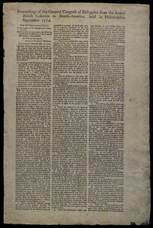
1774/10/20
Continental Congress (1774)
Extracts from votes and proceedings of Continental Congress
Full title: "The following extracts from the votes and prceedings of the American Continental Congress, we are induced to publish early purely to ease the impatience of our readers. Association & C." Printed by T[homas] R. J. Fleet.
GLC02668
9 December 1801
Gleason, John (fl. 1796-1811)
[Copy of a survey map of land sold by Henry Knox to B. Joy of Boston]
Gleason and Robert Houston sign as surveyors. Depicts 16,340 acres of Waldo Patent land flanked by these notations: "Green, Waldo Heirs, Knox, Belfast, Northport, Lincolnville, and Bonapartte." A list of names is written in pencil within the area...
GLC02437.10341
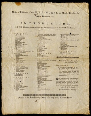
circa 30 November 1783
New York (N.Y.). City Council.
Order of exhibition of the fire-works, on Monday evening the first of December, 1783.
Program for a fireworks display, showing the order in which the different fireworks will be set off and prohibiting other illumination in the city on the night of the exhibition unless specially authorized. In the title, the word "first" has been...
GLC02437.10571
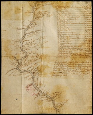
23 July -6 August 1784
Galbraith, P. Bartrem (fl. 1784)
[Map of the Susquehanna River]
Drawn map of a portion of the Susquehanna River, with creeks, forts, and ferry landings noted. Also includes the distances to various points on the map. Noted as drawn above Canawago Falls, which is in Pennsylvania.
GLC02437.10583
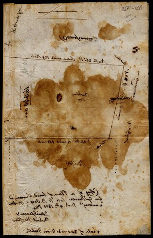
1792
Pierpont, Joseph (fl. 1792)
[Map of land]
Map of the land by the Penobscot River. Water is drawn with blue watercolor ink. Shows the division of land into different plots.
GLC02437.10593
1795
Map of surveyed land possibly located in Maine. Titled, "THE SOUTH LINE OF the 50000 Acres Run By John Gleason Junr 1795 No 1." Covers three miles and a half of land and includes notes on the quality of land. Document is partially printed with...
GLC02437.10598
circa 1782
Erskine, Robert (1735-1780)
[Map of South Carolina]
A manuscript copy of a printed map of a portion of South Carolina. Shows lakes, rivers, streams, forest, towns, counties, and possibly roads. Noted, "Part of SOUTH CAROLINA copied by R. Erskine F. R. S. from A Map published in London 1771." Docket...
GLC02437.10611
30 March 1774
Flucker, Thomas (1719-1783)
A drawn map of land, likely located in Maine, deeded to Francis Waldo from Thomas and Hannah Flucker. Shows lakes, rivers, and boundary lines. Date taken from docket.
GLC02437.10645
4 July 1781
Storers, Christain (fl. 1781)
[Sketch of land]
Charles Miller signed the docket on 2 November 1801. A sketch of Christian Storers' surveyed land lying in "Waldowborough" [Waldoborough, Maine]. Includes written information regarding boundary lines and a drawn compass showing cardinal directions...
GLC02437.10646
circa 1796-1806
A sketch of land surveyed by John Gleason. Cover 50,000 acres of land likely located in Maine. Shows a pond and various land marks in water colors and has a partially colored border.
GLC02437.10650
circa 1784-1806
Unknown
A drawn map of lands near the Penobscot River in Maine. Land is noted as belonging to the heirs of Brigadier [General Samuel] Waldo. Lakes and rivers are noted in blue water color. Includes a drawn compass showing cardinal directions.
GLC02437.10652
circa 1790
Noted as a copy. Drawn sketch of a plan for the northwestern part of the Waldo Patent located in Maine. Depicts county lines and the northern and western boundaries of the Waldo Patent. Date was added later in pencil.
GLC02437.10666
circa 1782-1783
Bauman, Sebastian (1739-1803)
[Map of Forts Ontario and Oswego and surroundings]
Docketed as "A rough sketch of Oswego by Major Bauman." Shows Fort Ontario (captioned), Fort Oswego (uncaptioned) and surrounding features (possibly earthworks).
GLC02437.10667
October 1781
[Map of Yorktown, Virginia]
Drawn map of Yorktown, Virginia. Shows roads, rivers, and other land markings, but not fortifications. With Cornwallis autograph note written across the front: "you will deliver the town immediately." Likely created by the British right before the...
GLC02437.10669
1774/09/17
Suffolk Resolves
The Suffolk resolves: Proceedings of the ...
Printed by John Holt. The first printing in New York of the Suffolk Resolves. Evans 13701
GLC02438
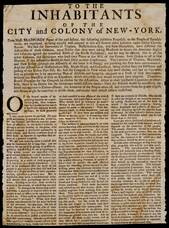
1774 ca.
To the inhabitants... re: calling for appointing delegates from NY to Congress
Printed by John Holt. Evans 13660. only 2 copies recorded
GLC02439
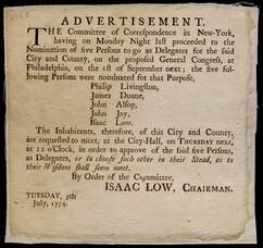
1774/07/05
Advertisement re: NY delegate nominations for first Continental Congress
GLC02440
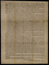
1776
New York. Legislature
In Provincial Congress [calling for election of revolutionary government]
Possibly printed by John Holt. Evans 14934.
GLC02442
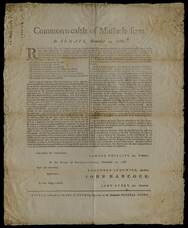
19 November 1788
Phillips, Samuel (1752-1802)
Commonwealth of Massachusetts
Commonwealth of Masachusetts set of resolutions to create separate districts within Massachusetts with representatives from each district. States the common dates for election of representatives and establishes that elected representatives must then...
GLC02444
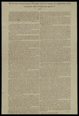
12 December 1874
Smith, Gerrit (1797-1874)
Will the American people never cease to oppress and torture the helpless poor?
Begins with an excerpt from the New York "Tribune" indicating that thirty-five black children were ejected from public schools in Brazil, Indiana, by order of local trustees. Smith criticizes the children's ejection and urges the Republican Party to...
GLC02448.20
no date
Map from Stratford to Poughkeepsie
This printed map appears to be cut out of a larger book or atlas. Neither Stratford nor Poughkeepsie is on the map. Has slight water damage/staining.
GLC02437.08401
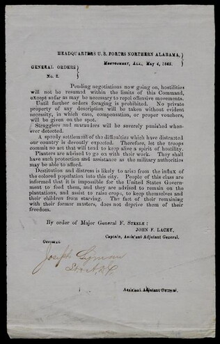
4 May 1865
Steele, Frederick (1819-1868)
General Orders no. 3
Signed official at bottom by Lieutenant Joseph Lyman, A.D.C. Orders that Federal troops are not to pillage homes and plantations since the hostilities of the Civil War have ended. Advises newly freed blacks to stay on their plantations with their...
GLC01908
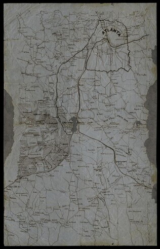
circa 1864
[Manuscript Civil War map of Atlanta and vicinity]
Detailed map on blue lined paper of Atlanta and environs from General Sherman's Atlanta campaign. Shows roads, railroads, forests, and rivers. Directions and latitude not given.
GLC01924
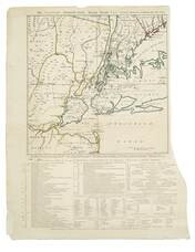
1 November 1776
Hawkes, W. (fl. 1776)
The Country twenty-five miles round New York
Irregular shaped paper. Engraving with letterpress chronological table of events from 1773-Oct. 1776, engraved by J. Barber and printed by W. Hawkes. Irregularly shaped. Nebenzahl, Battle Plans of the American Revolution, 110, who notes that a later...
GLC02005
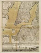
Ratzer, Bernard
Plan of the City of New York in North America
Engraved by Jeffrey and Fagan. Oversize engraving showing lower Manhattan Island, part of Brooklyn and Hoboken, N.J. A cartouche extending across the bottom has a panoramic "South West View of the City of New York." Based upon the survey of 1766...
GLC02006
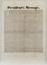
1829
Jackson, Andrew (1767-1845)
President's message
An Extra of the Hartford Times, reporting from telegraph the text of Jackson's first State of the Union. The address discusses what will be many of the major issues during his Presidency. Discusses removal of Native Americans, questions the...
GLC02009
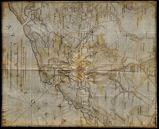
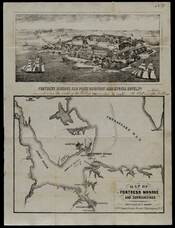
1861 circa
Bohn, Casimir (fl. 1849-1861)
Map of Fortress Monroe and surroundings
Includes an engraving with hand-written indications of where camp, mill creek, and a bridge are located. The map also indicates where fighting occurred and the course of the soldiers.
GLC02016.007
[Map of islands on the Sea of Okhotsk]
A hand-drawn map on linen of islands in the Sea of Okhotsk located on the coast of Russia between the Kamchatka Peninsula and Sakhalin Island. The map contains numbers throughout and depicts such places Big Shantar, Little Shantar, Bear Island, and...
GLC02016.181
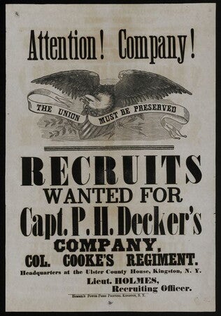
1862
Lieutenant Holmes (fl. 1862)
Attention! Company! [Recruiting broadside for New York 156th Infantry]
Announcment made by Lieutenant Holmes, the recruiting officer of the regiment. His first name could not be discovered. Printed by Hommel's Power Press Printing in Kingston, New York. Depicts large eagle holding scroll reading "The Union must be...
GLC02028
15 April 1865
McClellan, E. (fl. 1855-1865)
Announcement of death of Lincoln
Announces the death of President Lincoln to the soldiers at the U.S. General Hospital. Signed on verso by Jacob Campbell, Company S, 2nd Regiment, PA with a short note bidding farewell to the "sacred evil of old Virginia."
GLC02030
26 August 1863
The Draft in Berks County
Extra from the "B. & S. Journal" -- the Berks and Schuylkill Journal. Broadside lists men drafted in the first Northern draft by town, with occupation, in Berks County, Pennsylvania. Lists the names of men from 16 different towns. Mentions number of...
GLC02036
1777
Faden, William (fl. 1750-1836)
A Plan of the city and environs of Philadelphia
Surveyed by N. Scull and G. Heap, engraved by William Faden. Includes military information relative to the American Revolution. Also has an inset image of Independence Hall, where the Declaration of Independence was adopted.
GLC02118
1783/04/12
George III, King of Great Britain (1738-1820)
Proclamation of Peace [Printed by John Hayes]
Tall, narrow broadside dated from Baltimore, April 12. "1783" has been added in roughly contemporary ink. A docket on verso has been obscured by age and modern restoration (possibly including bleaching). Apparently, the only recorded copy of the...
GLC02122
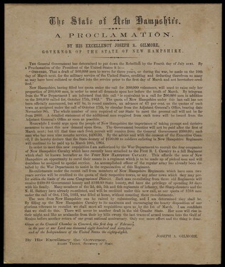
1 February 1864
Gilmore, Joseph Albree (1811-1867)
[New Hampshire proclamation to meet the draft quota]
Proclamation promulgated by New Hampshire Governor Gilmore and New Hampshire Secretary of State Allen Tenny. Encourages the enlistment of New Hampshire citizens, who "will rise in their might and like an avalanche... sweep the last traces of armed...
GLC02125
1846
Mitchell, Augustus S. (fl. 1846)
Map of Texas, Oregon and California [pocket atlas]
Full title: A New Map of Texas, Oregon and California with the Regions Adjoining. Compiled from the Most Recent Authorities. First printing of this landmark map of the American West. Baughman, Kansas in Maps, p. 35. Graff 2841. Howes M685. Martin &...
GLC02130
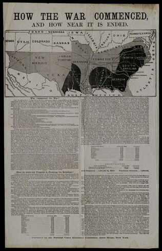
1 October 1864
National Union Executive Committee (1864)
How the War Commenced, and How Near it is Ended
Published by the National Union Executive Committee, Astor House, New York. Issued during the reelection campaign of Lincoln. Heavily criticizes the rhetoric of the Confederate States and the Chicago Convention. Contains a map (12.7 x 28.6) and...
GLC02133
4 April 1899
Dewey, George (1837-1917)
Proclamation to the people of the Philippine Islands
Title continued: "The Treaty of Peace between the United States and Spain, ratified several weeks ago by the former, having on March 20th been ratified by the latter, the cession to the United States...."
GLC02134
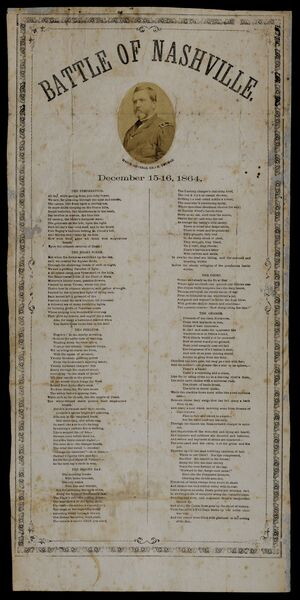
15-16 December 1864
Battle of Nashville
Six stanza poem dramatizing the action at the Battle of Nashville. Each stanza has a heading: "The Preparation," "The Night Scene," "The Prelude," "The Second Day," The Chief," and "The Charge." The stanza titled "The Chief," is the shortest and is...
GLC02135
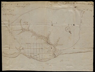
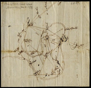
8 January 1777
[Map of roads in the vicinity of Morristown, New Jersey]
Indicates roads, some natural features, landmarks ("court house," "Whites Tavern Genl Lees," bridge, landing, etc.), outlying towns, and distance between points on the map. Indicates the location of towns surrounding Morristown. Notes the position...
GLC02437.09543
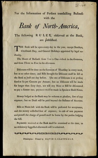
circa April 1782
Claypoole, David C. (ca. 1757-1849)
For the information of Persons transacting Business with the Bank of North-America...
Details rules and regulation for those who want to do business with the Bank of North America. Includes business hours, and rules regarding payment, savings and bank notes and bills. Noted as printed in Philadelphia by David C. Claypoole.
GLC02437.09980
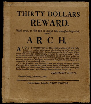
7 September 1791
Davis, Ignatious (1759-1828)
Thirty Dollars Reward
Printed by John Winter of Frederick-Town (now known as Frederick), Maryland. Broadside which announces Ignatious Davis's offer of a 30 dollar reward for his runaway enslaved person Arch. He is described as "a handsome Negro Lad ... About twenty years...
GLC03157
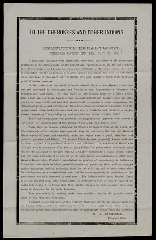
30 July 1885
Bushyhead, Dennis W. (1826-1898)
To the Cherokees and other Indians [tribute to the memory of Ulysses S. Grant]
References: Gilcrease-Hargrett p. 69. Hargrett, OK Imprints 554
GLC03165
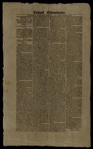
20 May 1797
Adams, John (1735-1826)
Centinel extraordinary.
Prints a speech given to Congress by President John Adams on Tuesday, March 16, 1797. Speech discusses suspending relations with France and the XYZ Affar. Printed in four columns.
GLC03180
Showing results 151 - 200